

Chicago's freaky February tornado event
Chicago - The last few days of meteorological winter have seen their share of extreme and unusual weather. It was another case of weather whiplash this week. Monday's high of 71 degrees at O'Hare shattered the old record for that date of 64 degrees.
Chicago set another record on Tuesday. O'Hare recorded a record warm low temperature of 52 degrees which shattered the previous record of 42. O'Hare hit a high of 74 degrees on Tuesday. That was just one degree shy of a record for the date and a record warm temperature for any winter day.
That late winter warmth helped fuel some powerful storms on Tuesday. Several severe thunderstorms spawned tornadoes in northern Illinois. Before Tuesday, Illinois had only seen eleven total tornadoes since 1970. We matched that total on Tuesday with eleven confirmed tornadoes in northern Illinois and Indiana.
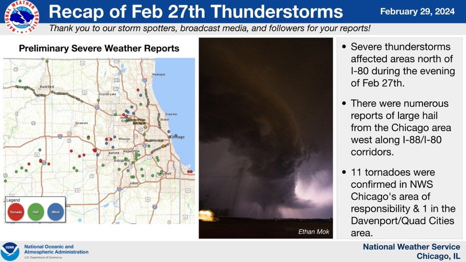
This severe weather event also produced tornadoes in Michigan and Ohio. There were also numerous reports of large hail, even up to baseball size, in several Midwestern states. Our area bore the brunt of the severe weather. It might sound cliché, but it is so true for this case; it could have been a lot worse. There were no major injuries in Illinois or Indiana.
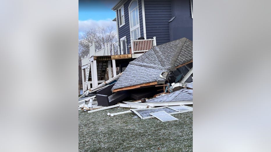
A gazebo destroyed by one of Tuesday's storms in Palatine.
I was in the Storm Force Tracker Truck the day after the tornadoes to follow up on storm damage. It was amazing that no one was seriously hurt after seeing large trees either blown over at their base or snapped into two pieces. The worst structural damage I saw was a large gazebo that was part of a homeowner's deck torn from the house and flattened.
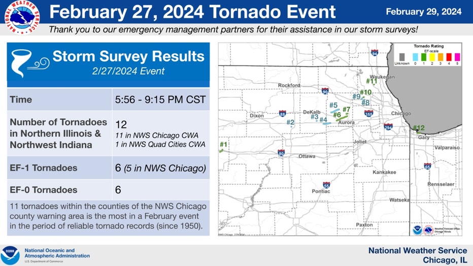
The National Weather Service survey crews investigated the damage from Tuesday's storms on Wednesday. They determined there were 12 total tornadoes between Illinois and Indiana. Eleven of those were within the Chicago National Weather Service office's area of responsibility. The strongest peak winds from the tornadoes that hit northeast Illinois got up to 95 mph with two EF-1 rated twisters.
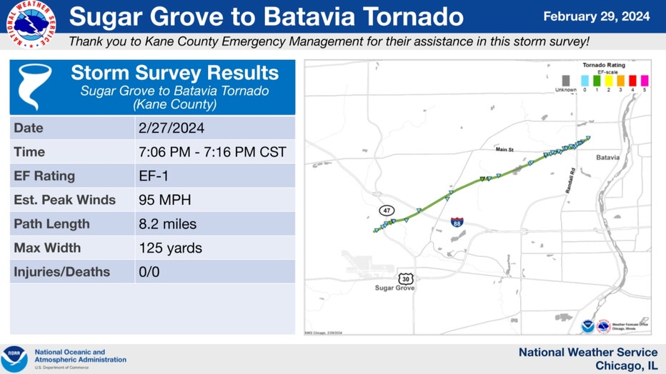
The Sugar Grove to Batavia tornado was one of the tornadoes to have winds that strong. The storm's path length was over 8 miles. It had a maximum width of 125 yards.
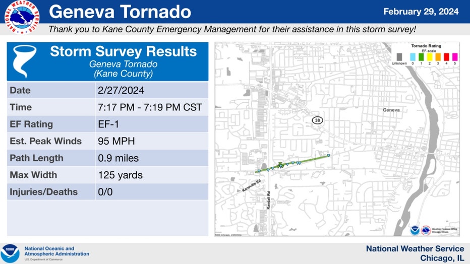
The Geneva tornado's winds were just as strong. It had a shorter path length of just under a mile. It also had a maximum width of 125 yards. The average width of a tornado is about 300 to 500 yards. The average distance a tornado travels is about 3.5 miles.
As of Friday afternoon, the National Weather has yet to post an update on the Mundelein or South Barrington tornado.
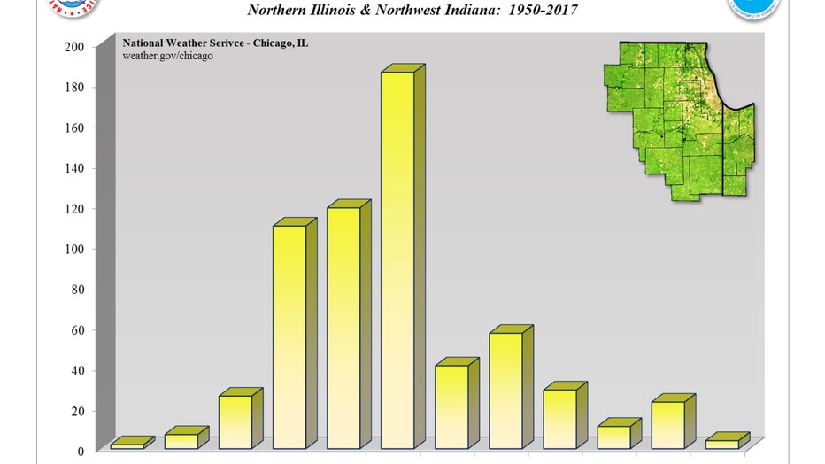
A study of tornadoes from the year 1950 to 2017 shows just how rare an Illinois or Indiana February tornado is. The vast majority of the tornadoes during this period occurred during the three-month period of April, May, and June. Collectively, those three months produced 57% of all the tornadoes over the 67-year span. February only produced 1% of the total number of tornadoes.

Here is another bar graph that illustrates the rarity of February tornadoes here. It shows the average number of days with one or more reports of tornadoes per month during the period of 2021 through 2020. The biggest spikes are seen during the months of May, June, August, and July. The number is much lower for February. Climate change may start to push these numbers higher across the board.
A new study suggests supercells (thunderstorms with rotating updrafts that are more likely to produce tornadoes) will become more common in parts of our country, including the Midwest, as our world warms.