

Tornado spotted in central Illinois as powerful storm system blasts through Midwest
CHICAGO - A powerful winter storm blasting portions of the Plains and Upper Midwest with blizzard conditions produced severe weather on Wednesday, putting communities south of Chicago on alert for powerful thunderstorms.
Forecasters said that while severe storms are expected, they won’t be anywhere near as violent as what took place last week when a deadly severe weather outbreak tore across America’s Heartland and South that left at least 43 people dead from Texas to North Carolina.
A Tornado Watch is in place for northern and central Illinois and western Indiana through Wednesday night. Another Tornado Watch is in effect for parts of southern Illinois, southern Indiana and western and central Kentucky through Wednesday night.
Louisville and Bowling Green, Kentucky are included in the watch through Wednesday at 11 p.m. CDT.
(LIVE Radar above)
FOX Weather Exclusive Storm Tracker Brandon Copic spotted a likely tornado near Stanford, Illinois, on Wednesday afternoon as a line of tornado-warned storms charged across the state southeast of Peoria.
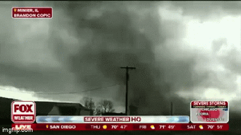
A tornado in Minier, Illinois seen by FOX Weather's Brandon Copic on March 19, 2025. (FOX Weather)
The first round of strong to severe thunderstorms developed earlier on Wednesday across portions of Nebraska and Iowa, bringing snow, blizzard conditions and even thundersnow.
Power outages have been rising throughout the day in Nebraska, Kansas and Iowa as blizzard conditions continue. A 74 mph wind gust was reported in Lincoln.
LIVE UPDATES: Tornado Watch in effect for parts of Illinois, Indiana
As the system continues to move off to the east, the threat of severe weather will increase from portions of the Midwest and Ohio Valley southward to Mississippi and Alabama.
The FOX Forecast Center said that sustained thunderstorm activity is expected to begin by Wednesday afternoon, and a few supercell thunderstorms could develop and form into a fast-moving line that will sweep across portions of Illinois and Indiana.
NOAA's Storm Prediction Center (SPC) has placed nearly 53 million people from Michigan and Wisconsin to the Deep South in the potential threat zone for strong to severe thunderstorms on Wednesday.
Damaging wind gusts, large hail and tornadoes are all a concern with the strongest storms.
However, the SPC has placed nearly 2 million people in an area just south of Chicago, from central Illinois to far western Indiana, in a level 3 out of 5 risk on its severe thunderstorm risk scale.
This level 3 risk zone, which includes cities such as Peoria, Decatur and Champaign in Illinois, faces the threat of strong tornadoes (EF-2 or higher).