What you need to know about Thursday's heat index in Chicago
Chicago - Sunday was the last day of a nine-day streak with highs hitting 80 degrees or hotter. It was the longest such streak in nearly 10 months. There were 14 straight days with highs at least in the 80s last year that started on July 26th and continued through August 8th. Despite our recent hot streak, this month is trending a bit below average. So far this July is a scant .1 degrees below average. The heat coming on Thursday could help us to eke out a warmer than average month overall.
The hottest day of the month (and year) was 93 degrees on June 24th. Our first month of meteorological summer has had some hot days, but we have been spared from extreme heat. Our hot days have not been particularly humid to this point. Humidity levels will be climbing by the end of the week, and it will have a noticeable effect on how we feel.
I thought it would be a good time for a quick refresher on the heat index. First, a few definitions that might help:
- dew point-the temperature to which a given air parcel must be cooled at constant pressure and constant water vapor content in order for saturation to occur
- wet bulb temperature-the lowest temperature that can be obtained by evaporating water into the air
- absolute humidity-the amount of water vapor in the air at a given moment
- relative humidity-the amount of water content in the air relative to the maximum amount of water content the air could hold
- dew point-the temperature the air needs to be cooled to (while held at constant pressure) for it to reach a relative humidity (RH) of 100%
The National Weather Service defines the heat index as "what the temperature feels like to the human body when relative humidity is combined with the air temperature". It is sometimes referred to as the "apparent temperature" or the "feels-like temperature". The topic of heat index is front and center in Houston as they begin their third week of record-breaking heat. Close to 50 million people in the south are under some type of heat alert. Heat index values in Houston have topped 120 degrees at times since the heat wave began. This is the kind of heat that kills. More than 700 people die annually from heat in our country. It is the leading cause of weather-related deaths.

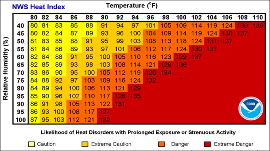
Most heat index charts show temperature (on the x-axis) versus relative humidity (on the y-axis). A temperature of 90 degrees with a relative humidity of 60% yields a heat index value of 100 degrees. This is where the temperature column intersects the relative humidity row for our example.

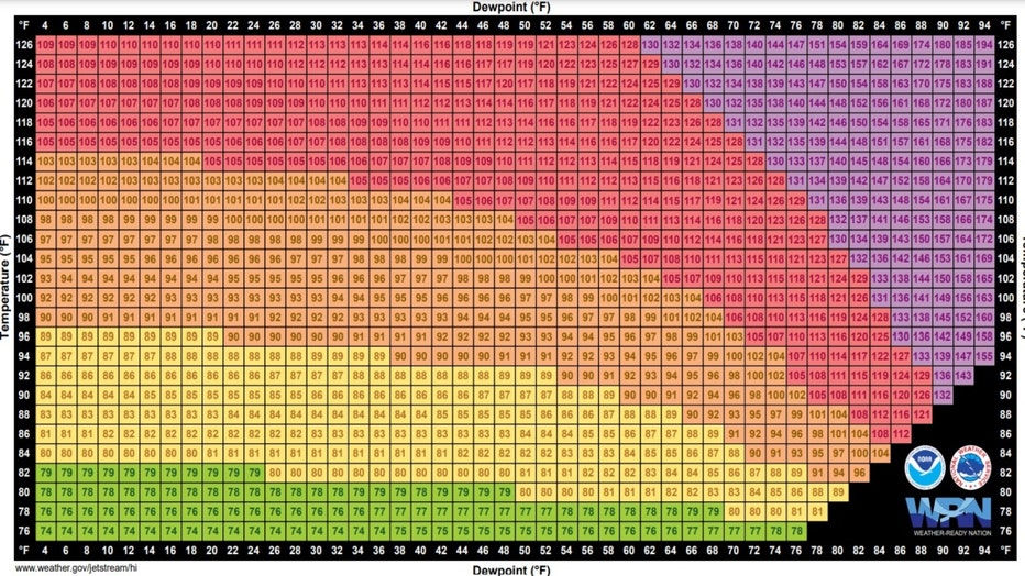
I prefer dew point over relative humidity as the way to measure the amount of moisture in the air. The relative humidity is dependent on the time of day, but the dew point is a more absolute measure of moisture at a given point in time.
Thursday's high should top out near 90 degrees with a dew point near 70 degrees. That would yield a heat index around 96 degrees. That is about as hot as it has felt so far this summer. That heat and humidity could fuel some strong storms at times. The Storm Prediction Center has us in the "slight risk" category for severe storms. That is level 2 out of 5.
The highest dew point ever recorded in Chicago occurred during a heat wave in 1999. The dew point on July 30th reached 83 degrees. It was like the tropics relocated to our city. Our body's can't use their natural cooling mechanism to sweat when dew points are that high. The highest heat index values ever in Chicago occurred during the deadly 1995 heat wave. The combination of heat and humidity made it feel like 125 degrees.
That type of heat is relatively rare here. Chicago was ranked as the country's 15th most humid city according to a study done by GoBankingRates that used data supplied by NOAA. San Francisco ranked #1, followed by New Orleans, Houston, Baton Rouge, and Seattle. It is important to note that the rankings were determined by averaging the morning and afternoon relative humilities at the cities included in their report. Although San Francisco topped the list, its average high during the middle of summer is in the lower 70s while Chicago's average high for the middle of summer is 85 degrees. The average relative humidity for a San Francisco afternoon is 69% and produces a heat index of 72 degrees during the height of summer there. In Chicago, that level of humidity in the middle of a typical July day would yield a heat index of 92 degrees for our city.
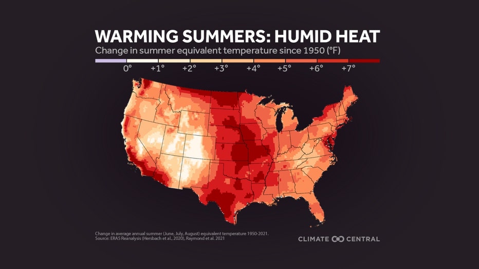
Climate Central did an analysis last year of the changes in "equivalent temperature" since 1950 across our country. They define equivalent temperature as a humid heat metric based on air temperature and specific humidity (the amount of water vapor in the air). Their report states that since 1950, the summer equivalent temperature has increased three times more than the summer air temperature on average for the contiguous United States. Chicago has seen its equivalent temperature increase by 5 to 6 degrees during that span.

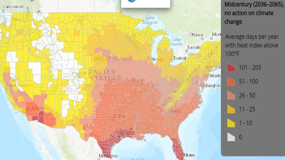
The Union Of Concerned Scientists hosts an interactive website that forecasts the increase in the average days per year with a heat index above 100 degrees. An analysis of Chicago shows it sees an average of 3 days per year with a heat index above 100 degrees. This includes an average of 1 day with a heat index above 105 degrees. In a "business as usual" scenario where no action on climate change is taken, the average amount of days in Chicago with a heat index above 100 degrees would soar to 24 days by the middle of this century. There would be 13 days on average per year that the heat index would rise above 105 degrees.


