Winter Storm Warning: Another Chicago Groundhog Day snowstorm is coming

Winter Storm Warning for Chicago area, snow totals update
A major winter storm is bearing down on the Chicago area. Emily Wahls has your snowy weather update!
Chicago - Eleven years ago, Chicago was in the middle of an historic Groundhog Day snowstorm.
A blizzard blasted the area laying down 21.2 inches of snow at O'Hare between Jan. 31 and Feb. 2 of 2011. It ranks as the third-worst snowfall in Chicago's history.
A jackknifed bus stopped traffic on Lake Shore Drive during the height of the storm, stranding several people in their vehicles that were backed up behind it. The city's 911 call center received almost 25,000 calls during the storm, with 350 coming from Lake Shore Drive alone.
DOWNLOAD THE FOX 32 CHICAGO WEATHER APP

Winds gusted up to 70 mph along the lakefront, whipping up the heavy snow that accumulated during the blizzard. Most of the Chicago area received between 18 inches to nearly two feet of snow.

This week's storm, that will begin in earnest on Groundhog Day, will not be as severe, but it will certainly be impactful.
We are not expecting blizzard conditions this time around. The strongest wind gusts may reach above 30 mph.
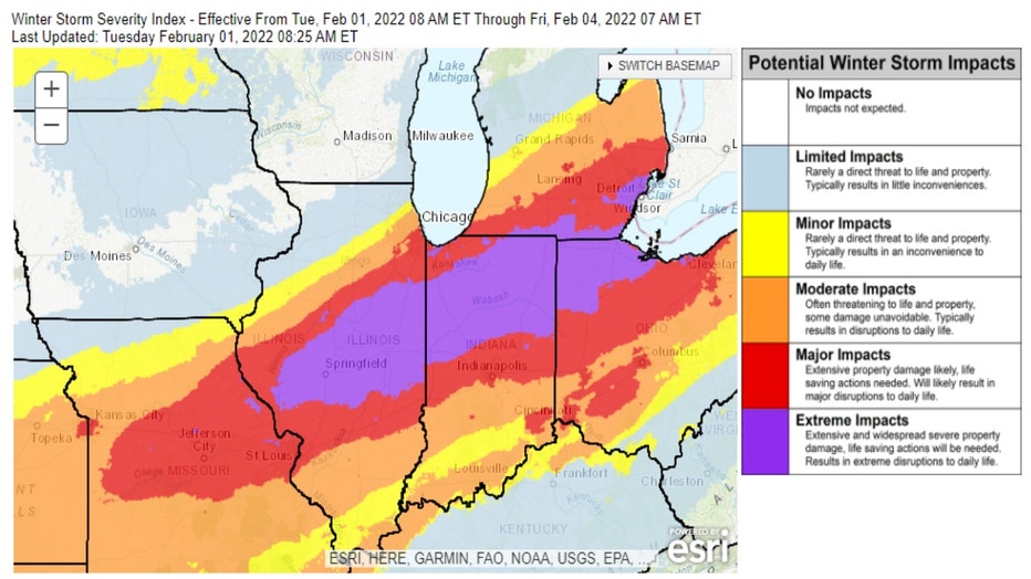
We also don't expect as much snowfall with this storm. The impacts will range from "minor", which means it is "rarely a direct threat to life and property" and "typically results in an inconvenience to daily life", to "extreme", which is defined as "extensive and widespread severe property damage" with "life-saving" actions needed. Extreme impacts also "results in extreme disruptions to daily life". The impacts for the city of Chicago itself is projected to be somewhere in between.

It might be better to define this as a snow event rather than a snowstorm. It may sound like splitting hairs, but this week's snowfall will come from a couple of different mechanisms that will produce a prolonged period of snowfall starting Tuesday night and lasting through at least early Thursday. The snow won't come from one single storm.

Keep that in mind as I share some model projections for snowfall.
These are total forecast accumulations through the entire event (Tuesday night through Thursday). The GFS model suggests 3 inches north of Chicago, about 6 inches to 10 inches in the city and over a foot south of Chicago.

The European model has similar numbers with 2 inches to 4 inches in our far northern suburbs, around 8 inches to 10 inches in most of Cook County and around a foot south of the city.

Our GRAF model falls in line with the other two models with a range from up to nearly 5 inches in Waukegan, around 10 inches in Chicago and over a foot south of the city.

These numbers are not set in stone and will undoubtedly change as we refine the forecast. It does give us a good idea of the character of the snowfall with this event.
A sharp cut-off is expected north and northwest of the city, several inches in Chicago itself and extreme amounts of snow south of Chicago.
Remember, a small shift in the track of the systems bringing this snow, a change in the intensity forecast and the eventual evolution and placement of lake-effect snow plumes would all change these projections.

