

Chicago weather: Weekend 'wildcard' snowstorm could impact travel plans

Chicago weather: Weekend 'wildcard' snowstorm could impact travel plans
Mark Strehl has your weather update!
CHICAGO - Chicagoland is preparing for a potentially significant snowstorm this weekend, followed by a blast of arctic air.
City officials are urging residents to stay informed and prepared as snowfall and extreme cold temperatures could impact travel and safety.
Friday's Snow Chances:
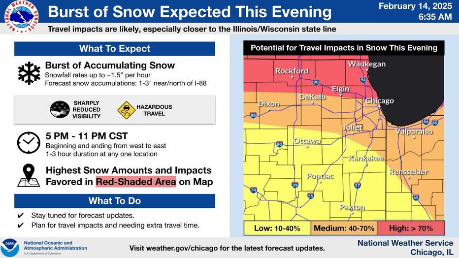
According to FOX 32 meteorologists, Chicagoland is expected to receive snow Friday night, with totals ranging from about an inch south of the city to up to three inches in northern counties.
Temperatures are expected to rise overnight, but another round of snow could arrive on Saturday.
Weekend Snow Showers :
Chicagoans can expect a mix of rain, sleet, freezing rain and eventually snowfall by Saturday evening.
Snowfall from Saturday night into Sunday could bring an additional 1 to 3 inches.
Another snow shower is also possible through midday Sunday before temperatures plummet.
Snowfall amounts could change between now and the end of the weekend, but FOX 32 meteorologists have acknowledged the potential for a "Weekend Wildcard" snow event. Stay informed with the latest weather updates here.
Frigid Temperatures:
On Monday, morning lows will dip near minus 2 degrees, with highs reaching 9 degrees.
Teens and single-digit temperatures will continue through midweek.
Travel Impacts:
Chicago's Office of Emergency Management and Communications (OEMC) warns that hazardous travel conditions could impact Friday evening commutes and overnight travel.
As the snow tapers off, bitter cold temperatures are expected to settle in Sunday night and continue through the week.
Warming centers will be available across the city, including public libraries, park districts, police departments, and city colleges. The city’s six community service centers will also be open during business hours, with the Garfield Community Service Center remaining open throughout the weekend, including President’s Day.
Residents can call 3-1-1 for assistance in finding a warming center.
What's next:
Residents are encouraged to monitor weather updates from FOX 32 and stay informed through the City of Chicago’s emergency alerts.
Travelers should prepare for potential disruptions and use caution on the roads throughout the weekend.
Those needing shelter from the cold can utilize the network of warming centers available throughout the city.
For more information, visit OEMC's website.
Kaitlin Cody's FOX 32 forecast
On Friday, snow will move in from the west roughly around 3-4 p.m., pushing east through the evening. The snow may come down heavily at times, decreasing visibility and leading to quick accumulations.
Through tonight, we have the chance for about 1-3" of accumulation with the heavier snow along and north of I-88. Tonight, into Saturday morning, we have the chance for freezing rain/drizzle to mix in roughly along and south of I-80.
Saturday will hold the chance for a light rain/snow mix. Highs on Saturday will be in the mid 30s. On Saturday night, the chance for snow is back and it lingers into early Sunday. There may be an additional 1-3" of accumulation through Sunday morning.

Sunday will be mostly cloudy with highs in the upper 20s. We dry out on Sunday and then the temperatures plummet. Lows on Monday and Tuesday morning are expected to be below zero. Wind chills in the morning on those days may hit -20 to -30.
Partly to mostly sunny skies are on the way next week from Monday through Thursday. Highs will be in the single digits Monday, around 10-15 degrees Tuesday and the mid to upper teens Wednesday and Thursday.
It will be a very cold stretch of weather next week, as our normal high at this time of year is in the mid 30s.
The Source: The information in this story was provided by FOX 32's meteorologists Mike Caplan and Kaitlin Cody, and Chicago's Office of Emergency Management and Communications.