Chicago's first real taste of winter is coming next week
Tim's Weather Takeaways: Chicago's first taste of winter
The cold weather is finally coming to Chicago, just in time for the holidays.
Chicago - If we hit our forecast high of 60 degrees today, it will mark the fifth straight day with highs in the 60s.
Friday should be our 6th straight day with temperatures above average. It has felt more like the middle of October than the middle of November this week. November is running nearly 5 degrees above average so far. If we finished the month that mild, it would be the third-greatest departure from average on the warm side of any month so far this year.
Unfortunately, we are in for a cold correction. A dose of December-like harsh reality will hit next week. The coldest air in eight months is coming just in time for our Thanksgiving holiday, and we may even squeeze out some light snow before then.

The typical last date we hit a high of 60 degrees or more is Nov. 25. The typical last day we hit a high of 50 degrees or more is Dec. 13.
After this weekend, we may not hit a high of 50 or warmer for eight days and at least a few days beyond that. Our Fox model eleven-day forecast shows the dramatic drop that is coming. Highs fall into the 50s this weekend, then fall into the 40s for Monday and Tuesday next week. That is followed by at least six straight days with highs only in the lower 30s.
The last time we strung together a cold streak like that was way back in late January and early February. Even before the coldest air arrives next week, we could get a smattering of light snow. Models suggest some flakes could fly late Tuesday into Tuesday night.

A VERY EARLY GFS model snowfall accumulation forecast through Tuesday night.
It's still too early to nail down the snowfall forecast numbers for next week, but the GFS squeezes out a dusting of wet snow. As of now, we don't need to break out the shovels, but there could be a dusting to a third of an inch of snow on the ground by midnight Tuesday if the model verifies.
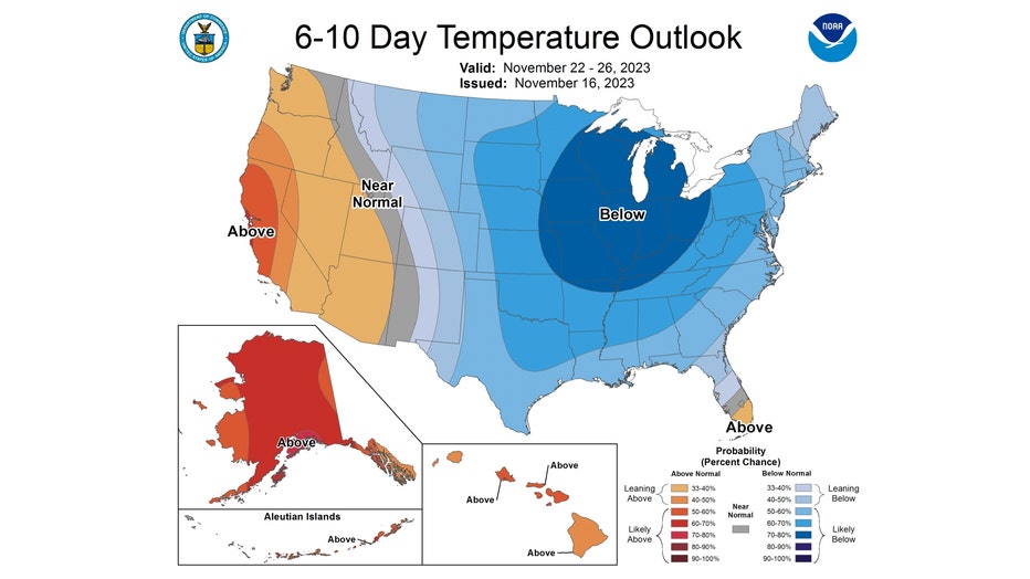
The longer-range temperature outlooks from the Climate Prediction Center are showing the most blue I have seen in a long time. This helps confirm what our Fox model is suggesting, that a cold pattern is about to kick in.

The 6-10 day temperature outlook has northern Illinois and Indiana either near normal or "likely below" normal overall. This covers the period from next Wednesday through the following Sunday. Blue on these maps indicates areas favored to be below average overall. The darker the shade of blue, the more likely that area will be colder than average. Blue covers this map from the Rockies through the East Coast.

The 8-14 day outlook keeps this colder pattern coming through the end of this month. It has all of northern Illinois and Indiana "likely below" normal again. This covers the period from the Friday after Thanksgiving through the following Thursday. Looking even longer range, there are signs from the models that this cold pattern may shift to a more mild (relative to average) pattern for most of December. Average highs for today are around 48 degrees and then fall to around 45 degrees by Thanksgiving. They drop to 42 degrees by the end of November and fall to the upper 30s by the end of the first week of December.

The forecast for a couple of weeks just beyond Thanksgiving removes all the blue from the Midwest. The 3-4 week temperature outlook favors us to be above average overall for the period that includes the final six days of November and the first eight days of December.

The monthly temperature outlook for December suggests a milder-than-average pattern is possible for the first month of winter. It has us "leaning above" average overall next month. Good news if you like your winters on the relatively warm side, but potentially bad news for snow lovers.

