

Chicago's first snow of the season is about to fall
Chicago weather: Get ready for the first snow of the season
Some scary "snow squalls" may haunt Chicago's Halloween this year.
CHICAGO - Our first snow of the season will fall on Tuesday. It may be our first, but we know it won't be our last. On average, we see 38.4 inches of the white stuff.
Only a smattering of snow is expected for Halloween, but that could be enough to make this one of the snowiest Halloweens in Chicago's history. Snow is rare on Halloween. In the past 150 years, only 2 Halloweens had measurable (.10 inches or more) snow. Six others had a trace.
I was able to give a heads-up on the Halloween snow last week in my blog post. The forecast hasn't changed much. The flakes that will fly on Tuesday are coming right on cue. The average date for the first trace of snow or more is October 31st. It may be jarring for some since this snow will come just a week after Chicago tied a record high of 83 degrees. October is running around 4 degrees above average, but the high on Halloween will be about 35 degrees colder than last Tuesday.
Will we need to break out the shovels? Probably not. Most models suggest less than a half inch. Temperatures will tumble into the middle to upper 20s by daybreak Tuesday so any snow early in the day may stick for a bit, especially on elevated surfaces and some rural roads. We will climb into the upper 30s for highs, so snow will have a hard time sticking later in the day.
There could be some minor accumulation though in the afternoon depending on the intensity and duration of the snow showers we expect. "Snow squalls" is a term we haven't heard in the forecast for quite some time. Here is the National Weather Service's definition of snow squalls:
A snow squall is an intense, but limited duration, period of moderate to heavy snowfall, accompanied by strong, gusty surface winds and possibly lightning (generally moderate to heavy snow showers). Snow accumulation may be significant.

If the snow squalls are intense enough, they could overcome the upper 30s expected in the afternoon and produce at least some minor accumulation.
The GFS model spits out some accumulating snow. It suggests around a tenth of an inch to nearly a half inch total tomorrow. This seems a bit overdone.
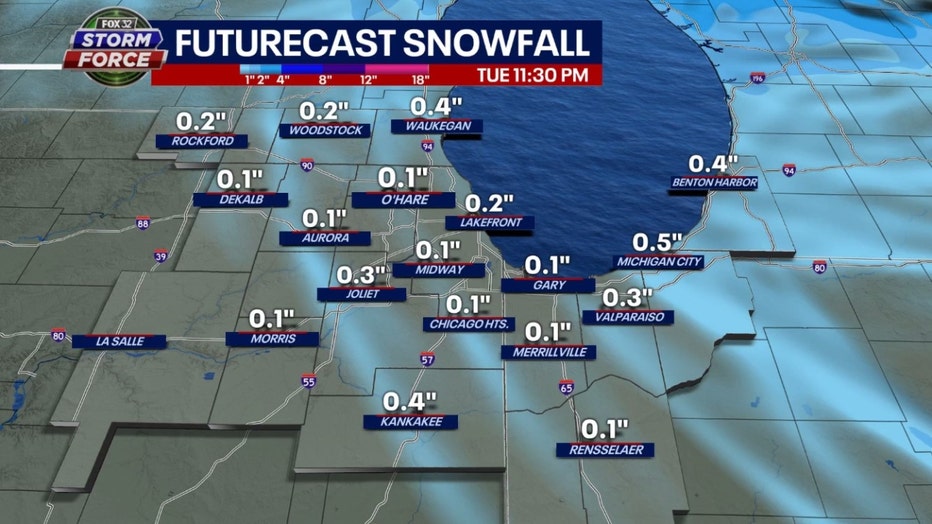
Our Fox Model spits out a little less snow overall with most locations getting about a tenth of an inch but a few spots getting a tenth or two of an inch more. It's the first snow of the season so stay tuned.
The forecast will be tweaked between now and early Tuesday.
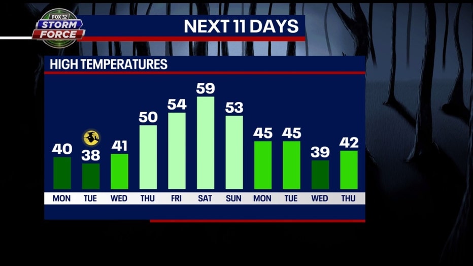
Not only could this be one of the snowiest Halloweens on record, it should be one of the coldest too. If my forecast high of 38 degrees verifies, it would be the 5th coldest Halloween in Chicago's history.
Notice Tuesday will probably be the coldest day of the next eleven. A week from Wednesday would be the next time to worry about potential snow again.