

Chicago's Novembers can bring nasty weather
Chicago's Novembers can bring nasty weather
Chicago-area Novembers have seen some nasty snowstorms, severe thunderstorms with tornadoes, and some extreme weather that was welcomed by most.
CHICAGO - October ended with a bang!
It was the fifth-coldest Halloween on record with a high of just 38 degrees. It was the second-snowiest Halloween on record with .9 inches of snow at O'Hare. October on average sees .2 inches of snow. So, we more than quadrupled the normal amount of snow we see for the month. We even had thundersnow on the 31st!
This begs the question, November started off chilly, but what will the rest of the month bring?
Average highs for the start of November are around 55 degrees and then fall to about 42 degrees by the end of the month. Lows start around 40 degrees on average and then fall to about 29 degrees. Those are the "normals" for November. I want to look at some of the not so normal and even nasty November weather we have seen throughout history here.
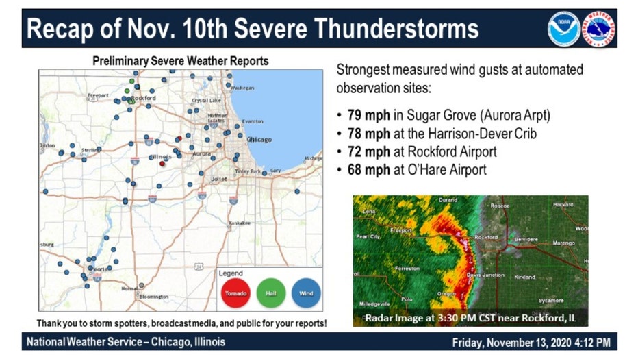
Just three years ago a squall line swept through northern Illinois and produced damaging winds.
On Nov. 10, 2020, these severe thunderstorms produced gusts of winds as high as 70 to 85 miles per hour. They brought down farm buildings and several trees near Mount Morris, the Rockford area, and portions of McHenry County near the Wisconsin state line.
There were even two brief EF0 tornadoes that spun up with maximum winds of 80 mph in a rural part of DeKalb County and near Lily Lake. Hail grew as big as one inch in diameter in Rockford. Since 1950, there have been 23 tornadoes to occur in the Chicago area during the month of November.
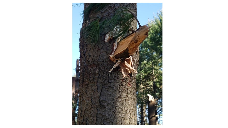
Damage near Mt. Morris courtesy of Kellie and John Call
The picture above shows the force of those winds. A large chunk of wood from one tree was impaled through another tree near Mt. Morris. At that time they were the first tornadoes to occur in the Chicago-area in seven years.
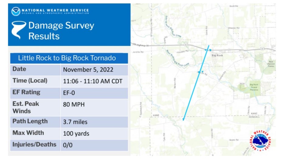
The most recent November tornado struck just last year. The twister touched down west of Aurora.
Here are some fast facts from the National Weather Service about the twister:
- On Saturday, November 5, 2022, a low-pressure system tracked along the Mississippi River while rapidly intensifying, leading to strong and damaging winds across northern Illinois and northwestern Indiana.
- Peak measured wind gusts ranged from 55 to 75 mph across the area, leading to widespread downed tree limbs, scattered power outages, and localized damage to building structures.
- Some of the strongest winds were associated with a narrow line of showers along a cold front. A wind gust of 77 mph was measured at DuPage Airport with the line.
- Additionally, the line of showers produced a brief EF-0 tornado with peak winds of 80 mph in mostly rural Kendall and Kane counties.
- For more on this event, see the event recaps put together by NWS Quad Cities, IL/IA and NWS Lincoln, IL.
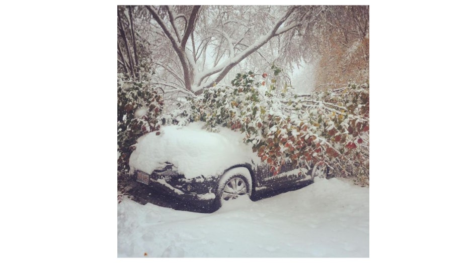
Heavy snow and wind caused damage in Buffalo Grove. Photo courtesy of Carrie Bernstein.
Significant snowstorms have struck during past Novembers. The second-worst November snowstorm hit just eight years ago.
Here are some fast facts from the National Weather Service in regard to the event:
- The first winter storm of the season for northern Illinois and northwest Indiana left a nearly 300-mile-wide swath of snow across portions of the Midwest. Over 16 inches of snow fell across far northern portions of Illinois. Snow began during the late afternoon hours of Friday, November 20th, and persisted through the late afternoon of Saturday, November 21st.
- The official snowfall for Chicago was 11.2" observed at O'Hare International Airport.
- The official snowfall in Rockford was 8.8" observed at Chicago Rockford International Airport.
- Other snowfall amounts include 4.7" at the NWS Chicago office in Romeoville, and 5.8" observed near (3 miles southwest) Chicago Midway International Airport.
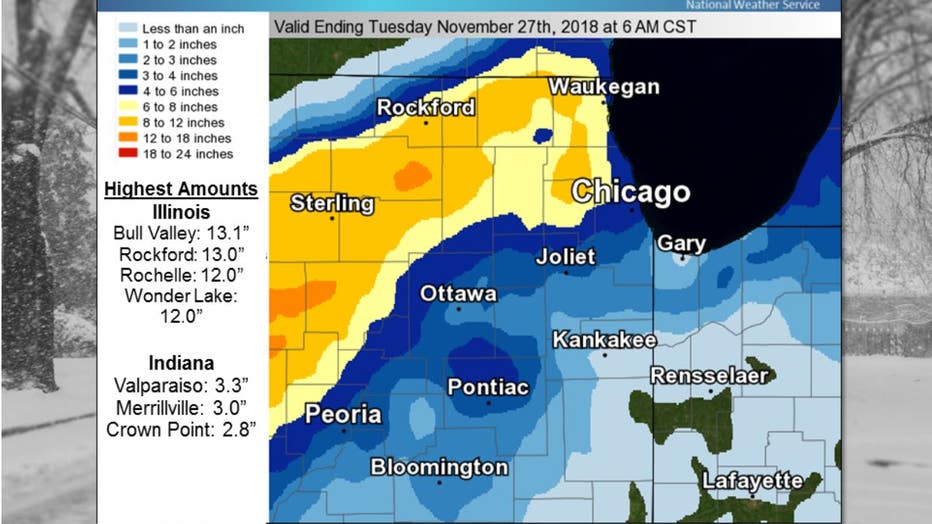
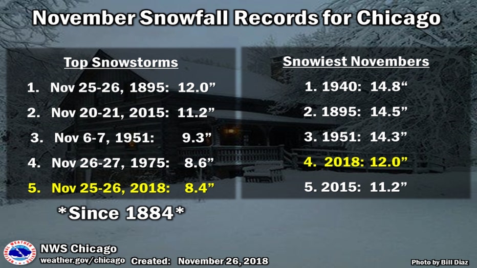
The fifth-worst November snowstorm impacted northern Illinois just five years ago. It was the largest snowstorm on record in November for Rockford. It laid down nearly a foot of snow in Rockford and 8.4 inches at O'Hare.
The storm hit on Nov. 25, 2018, in a particularly snowy month. We ended up with 12.7 inches in total at O'Hare making it the fourth-snowiest November on record in Chicago. It was the snowiest November on record for Rockford with a total of 15.6 inches.
Not all November significant weather events are nasty.
November of 2020 made it into the record books because of how mild the month started. Highs hit 76 degrees on both Nov. 8 and Nov. 9 which tied with two other days for the 8th warmest November on record. At the time, it was the warmest November temperatures in over 40 years here. We average one November day in the 70s but that November had seven consecutive highs in the 70s.
Temps in the 70s are still not out of the question according to the longer-range temperature outlooks from the Climate Prediction Center.
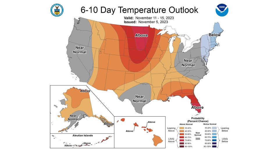
The 6-10 day temperature outlook has most of northern Illinois "leaning above" normal overall. This covers the period of Saturday through the following Wednesday. The blob of orange and brown grows bigger for the middle of the month.
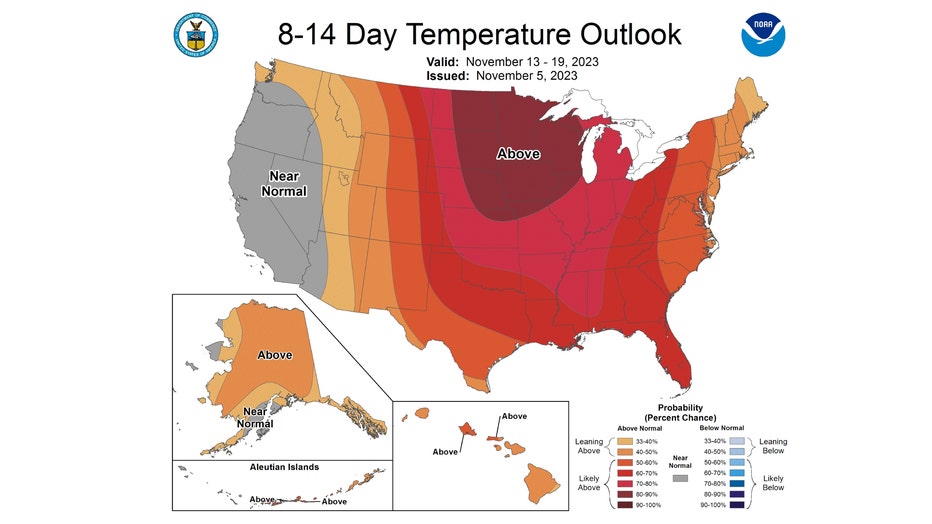
The probabilities of a warmer than average pattern increase in the 8-14 day outlook. It has northern Illinois "likely above" normal from next Monday through the following Sunday.