Chicago's winter is past the halfway point
Chicago's winter is halfway over
The worst of winter is behind us in Chicago. We braved the heavy snow and extremely cold temperatures, and now above-average temperatures are returning.
Chicago - Not only have we made it past the halfway point of winter in Chicago, but we are more than a week beyond that mark.
Sometime around Jan. 14 or 15 could be considered midway through the season. Winter is 91 days long and Jan. 14 marked the 45th day of the season. This winter began fairly benign with temperatures well above average overall through December and into the first several days of January. Just two days of December dipped below average and the first twelve days of January were all above.
Winter has hit the hardest over the past couple of weeks, taking an abrupt turn for the worse. Monday marked the 10th straight day with below-average temperatures. Twelve of fifteen days in a span that ran from Jan. 5 through Jan. 19 had snow reported at O'Hare for a total of 16.1 inches. That's more than half the snow we get in an entire winter here on average.
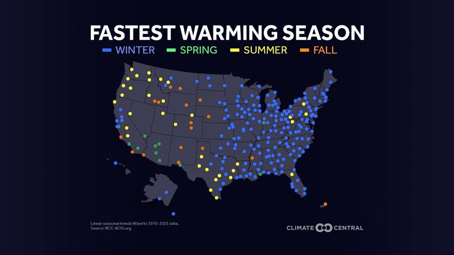
It may be hard to believe because of our recent rounds of bitter cold and snow, but winter is warming the fastest of all four seasons here in Chicago. 74% of 246 U.S. locations studied by Climate Central showed their winters were warming faster than any other season. The highest concentration of locations experiencing this were clustered in the Great Lakes, Midwest, and Northeast regions. A separate study by Climate Central gives us at least one reason why this is happening. We are seeing fewer frigid nights.
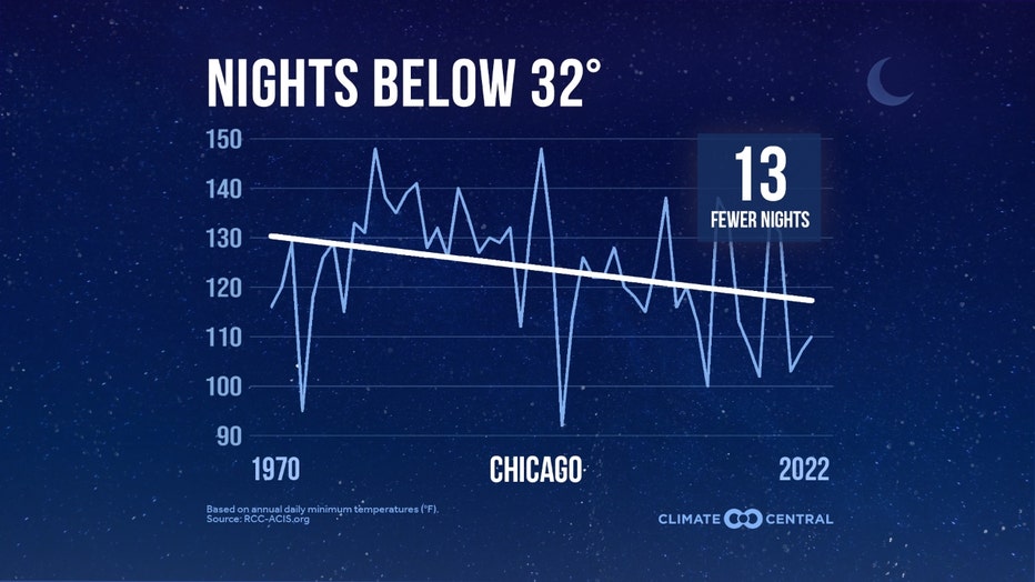
Climate Central analyzed 231 U.S. locations that had at least one day at or below freezing in at least half the years between 1970 and 2022. 204 or 81% of those locations have seen a long-term decline in the annual number of freezing nights during the period studied. On average, Chicago is experiencing 13 fewer nights below freezing as of 2022 compared to 1970. The rate of warming for our nighttime lows across the U.S. since 1900 is about 25% faster than the rate of warming for daytime highs. Highs and lows are both warming and both are contributing to warmer winters.
We have warmer winter weather coming in our forecast and the milder pattern that begins this week could hang around through at least the first few days of February. The longer-range temperature outlooks from the Climate Prediction Center strongly suggest a relatively milder pattern through this month and into the start of the next.
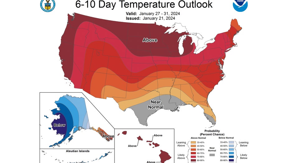
The 6-10 day temperature outlook forecasts northern Illinois and Indiana to be "likely above" normal overall. This covers the period from Saturday through the following Wednesday. We have between an 80% to 90% probability of being above average overall. There is no blue showing up anywhere on this forecast for the contiguous United States. That means no portion of the country is forecast to be below average overall.
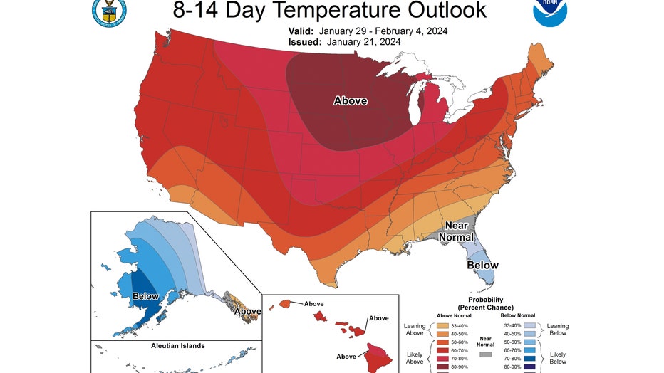
The strong signal continues with the 8-14 day temperature outlook. It also has us "likely above" average. This covers the period from next Monday through the following Sunday. It also shows an 80% to 90% probability of being warmer than average overall.
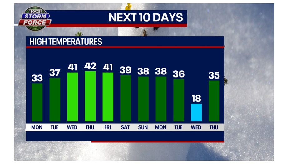
Our long-range Fox Model concurs with the Climate Prediction Center. It has 10 of the next 11 days hitting highs above average.
So we have finally turned the corner on what is typically the worst part of winter. There is more good news. We gain about two minutes a day of daylight through the end of this month. Next Monday will be the first time this year our sun sets past 5 pm. There is light at the end of our winter tunnel.

