

Chicago winter outlook: When to start worrying about snow
Chicago - Fall usually brings the first flakes of snow to Chicago.
Portions of our country have already seen the first snow of the fall. The largest ski resort in Idaho saw snow on its mountain summit earlier this week. The higher elevations in parts of Oregon, Washington, and Montana will see at least a few flakes this week.
When do we need to worry about stellar dendrites dotting northern Illinois? That is the fancy name for the most familiar form of snowflakes found here.
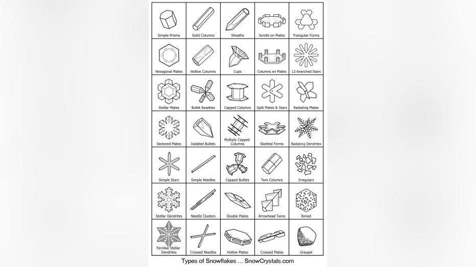
The wide variety of snowflake types.
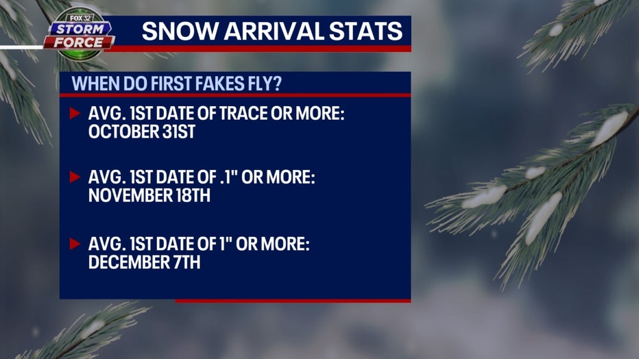
The typical first date for a trace or more of snow is right around the time you hear the phrase "trick or treat?" On average, snow falls for the first time on Oct. 31. That's the average date, but it can come much earlier or hold off until much later.

www.barrybutlerphotography.com/
The earliest first trace of snow has fallen on Sept. 25 in two different years. Snow fell on Sept. 25, 1928, and 14 years later on Sept. 25, 1942. The latest first snowfall occurred on Dec. 5, 1999.
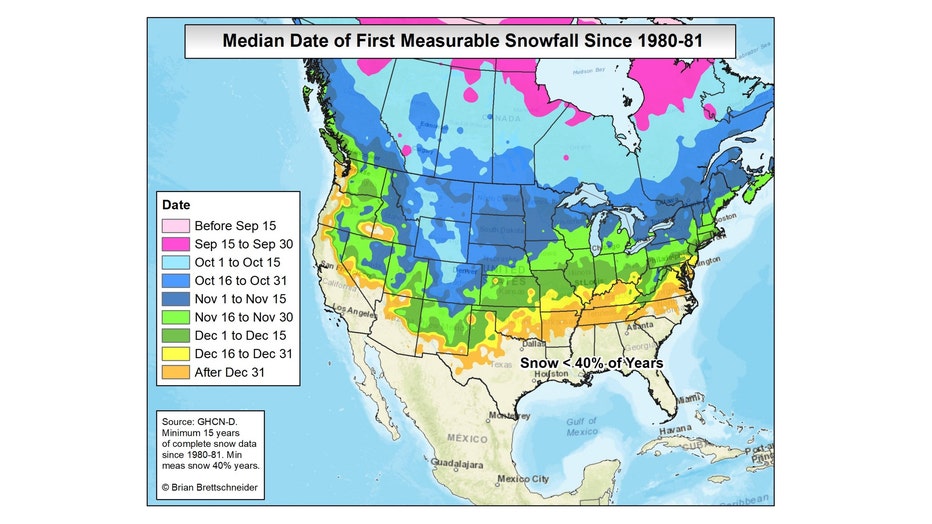
Map courtesy of Climatologist Brian Brettschneider
The average date of the first measurable snow (.1" or more) is on Nov. 18. It has fallen as early as Oct. 12 and as late as Dec. 28. We set the record for latest first measurable snow of the season just two years ago. We had to wait until after Christmas to get our first snowfall in 2021.
The average date for the first inch or more of snow is Dec. 7. It has arrived as early as Oct. 19 and held off as late as Jan. 25.
So September can bring a few flakes of snow, but we really don't need to worry about wintry-like weather until late October. It wasn't too long ago the ground here was covered in white just in time for Halloween.
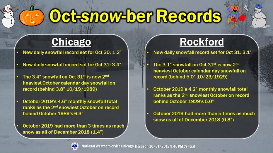
October 30-31, 2019 snowfall stats
We got more of a trick than a treat four years ago this Halloween. An early-season snowstorm produced record snowfall at O'Hare not only on Halloween but also the day before. 1.2 inches fell on Oct. 30, 2019, for a new daily record. The next day 3.4 inches fell on Oct. 31, 2019, which also broke the daily snowfall record.
Here is a summary of the snowfall event from the National Weather Service:
- The official snowfall for Chicago on Oct 30 was 1.2" observed at Chicago O'Hare International Airport, breaking Chicago's previous daily record for Oct 30 of 0.7" set in 1923.
- The official snowfall for Chicago on Oct 31 was 3.4" observed at Chicago O'Hare International Airport. This breaks Chicago's previous daily record for Oct 31 of 0.1" set in 2014. Halloween records and data can be found here.
- This made October 2019 the second snowiest October on record in Chicago with 4.6" falling not far behind 6.3" in 1989.
- With the previous winter lingering through April and this early season snow, there was not much time between snowfall events for the off season. In fact the 185 days between accumulating snow events (>= 0.1 in) for Chicago was the 6th shortest stretch of days on record for the city. When looking at between 1"+ events, the 185 days was actually tied for the shortest stretch with 1967.
- The official snowfall for Rockford on Oct 29 was 0.5" observed at Chicago Rockford International Airport.
- The official snowfall for Rockford for the Oct 30-31 system was 3.7" with 3.1" observed on Oct 31. This breaks Rockford's previous daily record for Oct 31 of 0.1" set in 2014.
- This made October 2019 the second snowiest October on record in Rockford with 4.2" falling not far behind 5.0" in 1929.
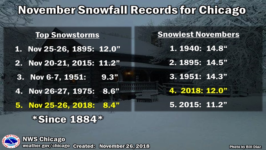
Just five years ago this November another snowstorm brought record amounts of snow to northern Illinois. Snow might not be unusual for the later part of November but the amount that came down Nov. 25-26, 2018, was unusual. It was the fifth-worst snowstorm on record for Chicago with a total of 8.4 inches falling over that two-day period. It was also the largest snowstorm on record in November for Rockford with a total of a foot piling up.
Here is the summary of that event from the National Weather Service:
- The official snowfall for Rockford was 11.7" observed at Rockford International Airport.
- This is now the largest snowstorm on record in November at Rockford.
- 11.7" on Nov. 25, 2018 set a new daily record and a November calendar day snowfall record.
- The November 2018 snowfall total is 11.7". As of November 26th, the snowfall total for November for Rockford is 15.6", making it the snowiest November on record in Rockford.
- Other snowfall amounts include 2.8" at the NWS Chicago in Romeoville and 4.9" observed 3 miles southwest of Chicago Midway International Airport.

What can we expect this winter in terms of snowfall? It is too early to make an accurate prediction but based on climatological records, somewhere around three feet would be typical.
The average snowfall for the entire snowfall season in Chicago is just over 38 inches. The trend over the past 50 years or so seems to favor above-average snowfall. Nine of the top 10 snowiest winters have occurred in the past 50 years. Nine of the top 10 least snowy winters have occurred 56 or more years ago.
Autumn, in particular, is helping to boost our snowfall numbers. A study by Climate Central noted that fall snow is increasing in Chicago.
So to sum it all up, no need to worry just yet about snowfall but just in case, start looking around the garage for your scraper.