

How frightful is the forecast for Halloween in Chicago?
How frightful is the forecast for Halloween in Chicago?
How scary will the weather be for trick or treaters? This years Halloween may be chilly in Chicago but the trend favors warmer Halloween nights for our future.
Chicago - The weather for Halloween this year may be more of a trick than a treat.
Monday and Tuesday could be collectively two of the coldest days we have seen since early March. There is even that scary four-letter word for precipitation in the forecast. You might want to consider a costume that has a lot of layers. Before I get to the forecast for Tuesday I wanted to look at the weather from past Halloweens.
Most of Chicago's Halloweens are cool and dry. The average high on Oct. 31 is in the middle 50s with the average low near 40 degrees.
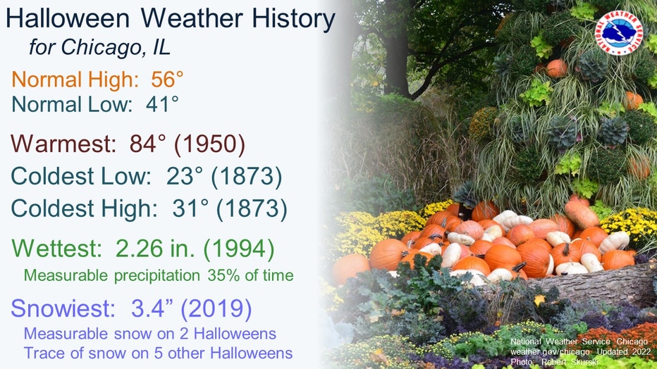
65% of Halloweens have no measurable precipitation but when it does fall, it can be either in the form of rain or snow. The typical first date for flakes to fly here in Chicago is Oct. 31. In the past nearly 150 years we have officially had snow on seven Halloweens. When it does snow this time of the year, the snowfall is rather light. 55% of the time we end up with a tenth of an inch of snow or less. Only 1% of Halloweens have seen more than a tenth of an inch of snow. Just four years ago we set a record for snowfall on Halloween when 3.4" fell.
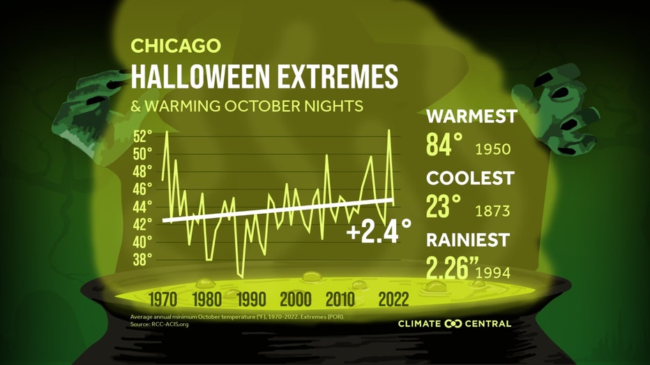
The thrill might not be gone for trick-or-treaters, but the chill isn't what it used to be. Halloween nights have gotten warmer on average since 1970. Climate Central did a study of 244 U.S. cities and their analysis reveals 89% of them have seen October nights warm between the period 1970 to 2022. Fall temperatures have warmed by nearly 3 degrees on average across the country during this period. More specifically, October nights have warmed by 2.2 degrees on average across the United States. Chicago's October nights have warmed by 2.4 degrees since 1970.
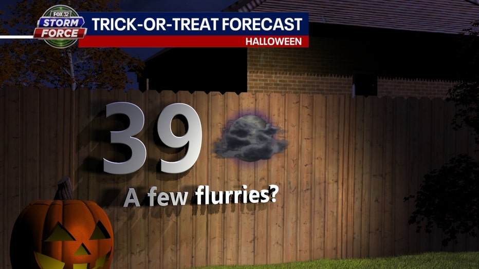
Unfortunately for some, the word "warm" is not in the forecast for Tuesday. The coldest air of the season so far will arrive in full force early next week. Highs on Halloween might only make it into the upper 30s for the coldest day in nearly eight months. To add insult to injury, there is even a chance for some flurries or snow showers. Primetime trick-or-treating temperatures will be in the lower 30s with gusty northwest winds making it feel like the 20s. Stay tuned since this forecast will at least be tweaked between now and then.
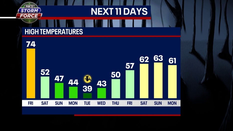
Our Fox Model has us falling into the 50s for highs Saturday, 40s for highs Sunday and Monday and then only upper 30s for Halloween. Notice the quick recovery by the following weekend. A week from this Saturday we could soar back into the 60s.
The longer-range temperature outlooks from the Climate Prediction Center also hint the colder pattern that is coming might not last too long.

The 6-10 day temperature outlook has most of northern Illinois "likely below" normal overall. This covers the period of Wednesday through the following Sunday. There is a lot less blue on the longer-range outlook that takes us just beyond the first week of November.
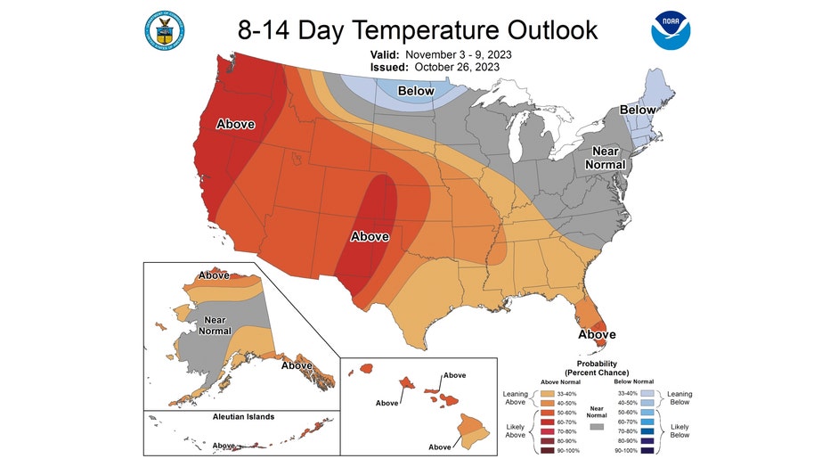
We may be transitioning back to a warmer-than-average pattern overall towards the middle of November. The 8-14 day outlook has a lot more orange and red than blue. It has northern Illinois "near normal" normal from next Friday through the following Thursday.
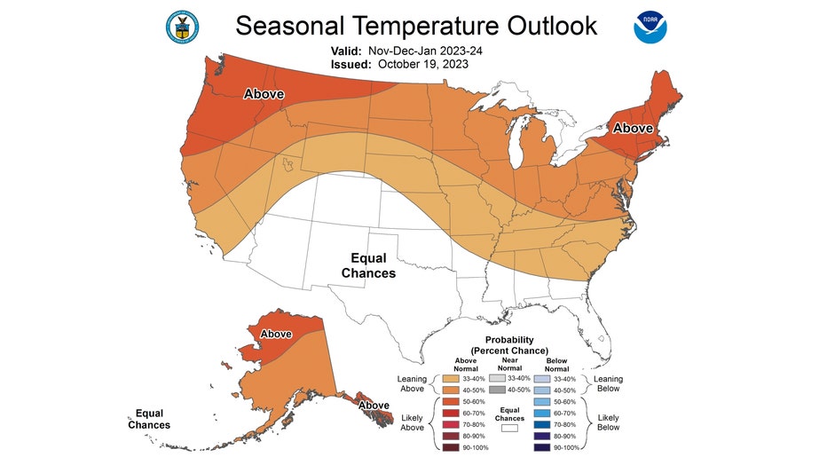
Looking at an even longer range forecast, the next three months are favored to be above average overall. This forecast looks very similar to the forecasts for the winter months of December, January, and February. It also has us "leaning above" average overall for the season.
In the meantime, try to stay warm trick or treaters!