How much snow does Chicago typically get the rest of the season?
How much snow does Chicago typically get the rest of the season?
We probably are not done with snow yet, according to climatological data for Chicago. On average, we pick up another 6.2 inches for the month of February, 5.5 inches during March, and 1.3 inches during April.
CHICAGO - If you plow snow or own a snowmobile, chances are you are disappointed with what winter has brought you so far in terms of snowfall.
We have seen 14.2 inches of snow for the entire season up until this point. That is more than 10 inches below average and only 57% of average to date. If we didn't pick up any more snow the rest of the season, this winter would rank as fourth least snowy season on record.
We probably are not done with snow yet, according to climatological data for Chicago. On average, we pick up another 6.2 inches for the month of February, 5.5 inches during March, and 1.3 inches during April.
We even average a trace of snow in May. From a strictly climatological forecast, we would see another 13 inches of snow based on historical record. In an average year we would have already seen about 66% of snowfall for the season with another 34% to come.
Everyone from Chicago knows that our winters are usually far from average. You don't need to look that far into our past to see some examples of significant snowstorms that have occurred late in the season.
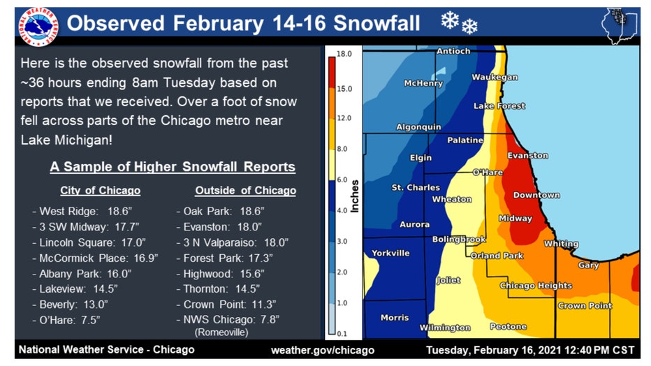
Snowfall amounts from February 14-16, 2021
Just two years ago next week we saw a February storm strike in the middle of the month that produced 7.5 inches of snow at O'Hare. There were many spots that saw much more. In and around the city of Chicago, 12-18 inches fell.
The snow depth of 21 inches at O'Hare reported on February, 16 was the highest snow depth recorded for Chicago in ten years. According to the National Weather Service, "the last time Chicago's snow depth was higher than 21 inches was in January and February of 1979, when on Jan. 14, it peaked at 29 inches, which is the record highest snow depth for the city of Chicago."
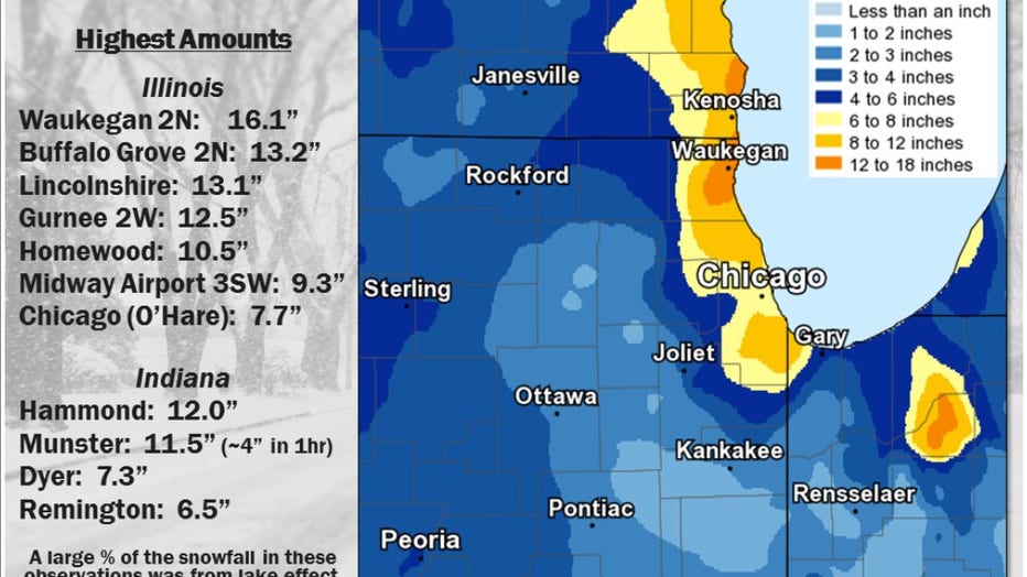
Snowfall amounts from March 12-15, 2017
A little over six years ago, a big snow hit in the middle of March. This storm produced 7.7 inches of snow at O'Hare. It was the largest March snowfall event for Chicago since 9.2 inches fell on March 5, 2013.
Parts of the area saw more than a foot of snow. Snowfall rates of between 2-4 inches an hour were reported in lake effect snow bands.

Snowfall from April 28th, 2019
Northern Illinois saw significant snow as late as April just over four years ago. The official snowfall as of 1 a.m. on April 28 of 2019 was 2.5 inches at O'Hare, the latest accumulating snow since May 6, 1989. It was also the latest 2 plus inches of snow on a calendar day on record.
What are our prospects for picking up more snow this season? The shorter term forecasts don't look too promising for snow lovers.
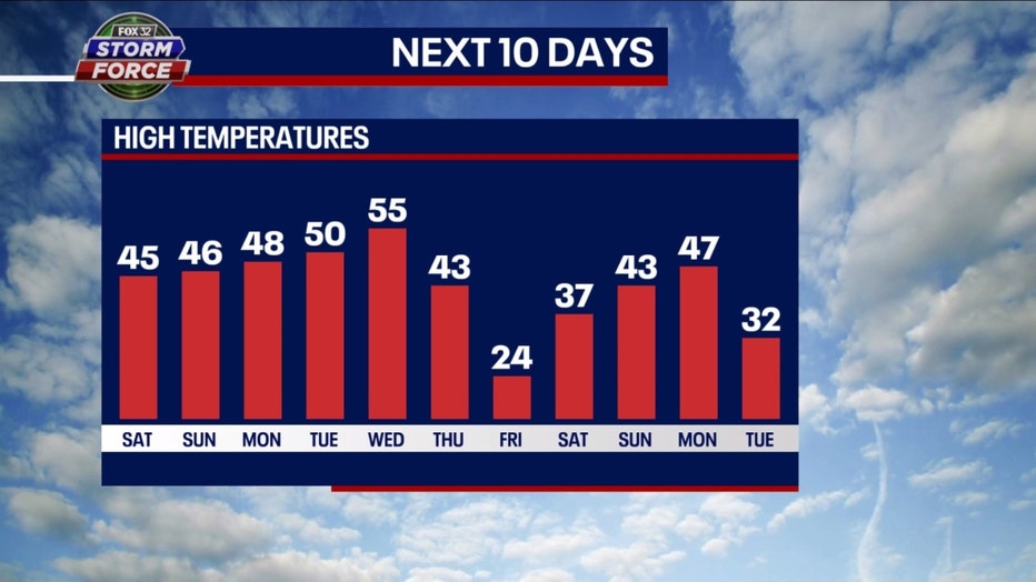
Our Fox model extended high temperature forecast only has a couple of days cold enough to support snow. Eight of the next 11 days are forecast to have highs of 43 degrees or more. Only two days of the next eleven will have a high of freezing or below.
The Climate Prediction Center's long range temperature outlooks have us in a relatively mild pattern just past the third week of February.
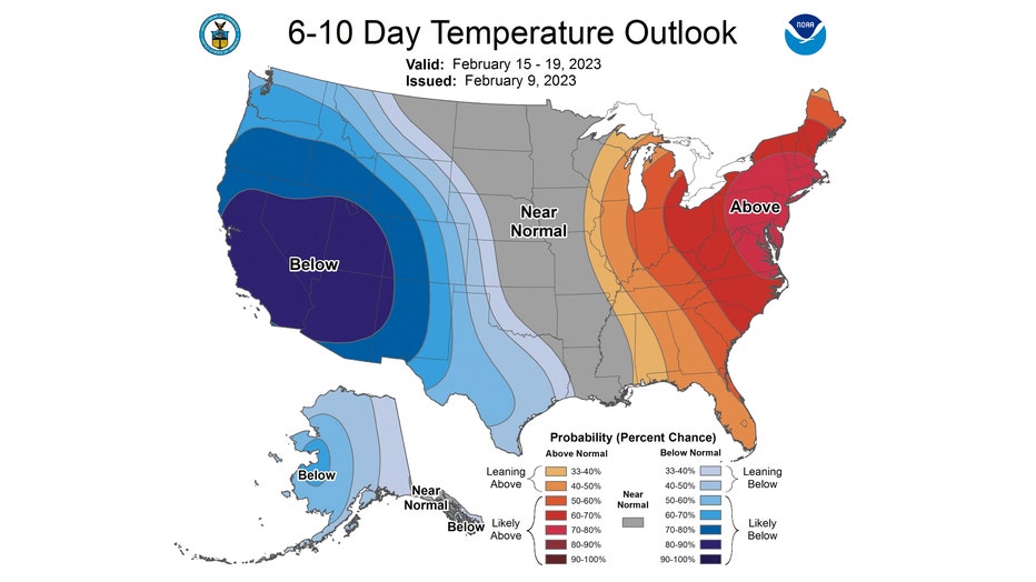
The 6-10 day temperature outlook has us either "leaning above" or "likely above" average overall for the period from next Wednesday through the following Sunday.
Since high temperatures this time of the year average in the middle 30s, this would suggest we will be at least a couple degrees above the freezing mark for highs most of the time.
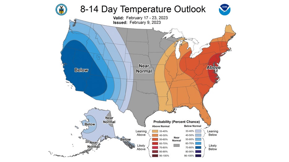
The 8-14 day temperature outlook still favors us for a mild February pattern. It has us "leaning above" average overall from next Friday through the following Thursday.
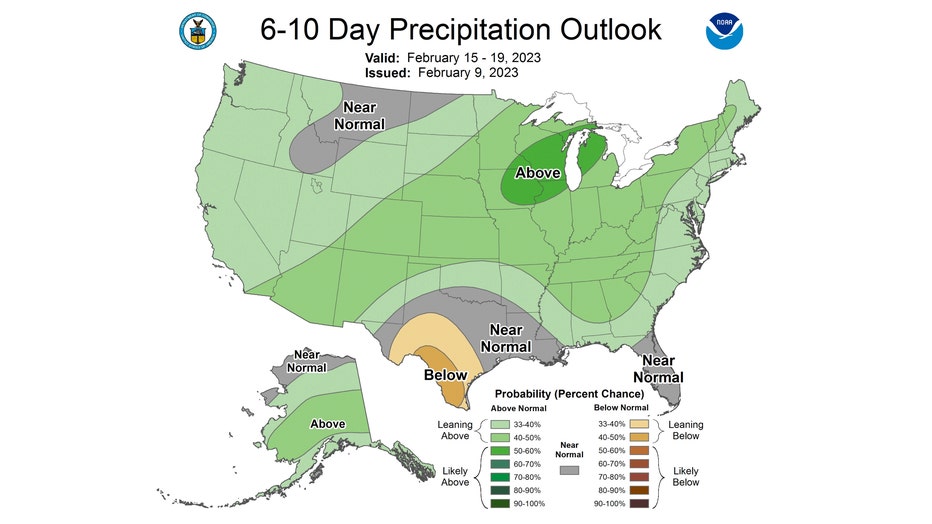
It appears the moisture will be there, but the temperatures may not be cold enough to cooperate for snowfall. The 6-10 day precipitation outlook has us "likely above" average for precipitation during the period.
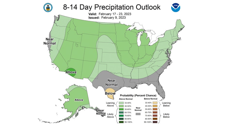
The 8-14 day precipitation outlook also us "leaning above" average for precipitation. The precipitation in these forecasts could come in the form of rain, snow or something in-between. These precipitation outlooks combined with the temperature outlooks favor plain old rain as the precipitation type.
I ran the GFS model total snowfall accumulation forecast out nearly two weeks to see how much snow might be squeezed out.
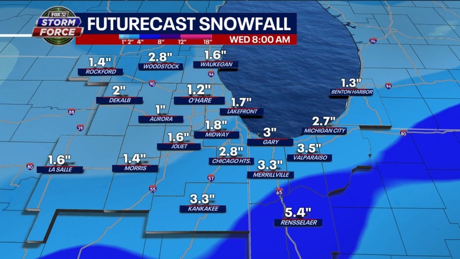
GFS Model Total Snowfall Forecast Through Morning Of 2/22
My usual words of caution can be applied here. These forecasts are fickle at best, so these numbers shouldn't be considered written in stone. That being said, the latest model run shows about 1 to 3 inches of snow in total during this period with the bulk of it falling on Feb. 21. Stay tuned.
I mentioned in a previous post that something called a "sudden stratospheric warming" could help make conditions more conducive for snowfall by the end of February and the start of March. Snow lovers need to keep their collective fingers crossed.

