

Hurricane Francine makes landfall in southern Louisiana
Hurricane Francine barreled into southern Louisiana on Wednesday evening as a category 2 storm, making landfall with destructive 100 mph winds and dangerous storm surge along the Bayou state's coastline.
The eye of Francine moved onshore at 5 p.m. CT in Terrebonne Parish continuing to bring hurricane-force winds inland into the southern region of the state near Baton Rouge. Minutes after landfall, power outages spiked in Louisiana to more than 42,500 without power.
Multiple parishes in Louisiana have issued mandatory evacuation orders as the Category 2 hurricane is set to make landfall Wednesday afternoon. State and local officials are urging residents to prepare for the storm's wrath, which is also expected to bring widespread power outages, significant flooding and substantial property damage.
Here's the latest on the storm (all times Eastern Daylight Time):
8 p.m.
According to the National Hurricane Center, Francine was producing life-threatening storm surge, hurricane-force winds, and heavy rains across southern Louisiana.
The agency urged residents to stay inside and away from windows and to have multiple ways to receive warnings and updates.
The general motion of this system should continue, taking the system across Southeastern Louisiana Wenesday evening and across Mississippi Thursday and Thursday night.
Maximum sustained winds were near 85 mph (140 km/h) with higher gusts. Rapid weakening is expected, and the system is forecast to become a post-tropical storm Thursday night or Friday.
Hurricane-force winds extended outward up to 40 miles fromthe center and tropical-storm-force winds extended outward up to 140miles.
6:15 p.m.
Hurricane Francine makes landfall with the eye moving across Terrebonne Parish.
5:15 p.m.
On Tuesday, Francine was upgraded to a Category 2 hurricane, the National Hurricane Center announced, adding that landfall was expected within the next couple of hours.
As of 5:15 p.m., Francine had winds of 100 mph and was moving Northeast at 17 mph.
"Life-threatening storm surge and dangerous winds occurring along the Louisiana coast," the NHC wrote.
The government agency said residents in the storm surge warning area should continue to follow advice given by local officials.
2:00 p.m.
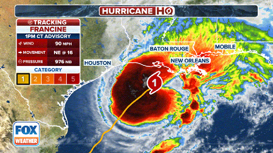
Here's the latest information on Hurricane Francine in the Gulf of Mexico. (FOX Weather)
The impending arrival of Hurricane Francine has Louisiana on edge. Dangerous conditions are expected to worsen throughout the day as the storm brings life-threatening storm surge and destructive winds to the state's coastline.
Rainbands from Francine continue to move onshore and spread inland into the southern region of the state. The National Hurricane Center (NHC) said tropical-storm-force winds are just offshore, and conditions will continue to deteriorate throughout the afternoon.
"Ensure you are in a safe location before the onset of these strong winds or possible flooding and have multiple ways to receive warnings," the NHC stressed in the latest advisory.
As of the 2 p.m. update, Francine is located about 120 miles southwest of Morgan City, Louisiana, or about 180 miles southwest of New Orleans, and moving northeast at about 13 mph. Maximum sustained winds are near 90 mph with higher gusts.

Here is the forecast track of Hurricane Francine. (FOX Weather)
11:15 a.m.
FEMA says President Joe Biden approved an emergency declaration for Louisiana, making federal disaster assistance available to the state to supplement response efforts. Here is the list of parishes included.
11:00 a.m.
As of the late-morning advisory from the NHC, Francine is located about 150 miles southwest of Morgan City, Louisiana, or about 210 miles southwest of New Orleans, and moving northeast at about 13 mph. Maximum sustained winds are near 90 mph with higher gusts.
10:00 a.m.
As of the latest advisory from the NHC, Francine is located about 195 miles southwest of Morgan City, Louisiana and moving about 19 mph. Maximum sustained winds are near 90 mph with higher gusts. Francine is expected to strengthen further into a Category 2 hurricane before or at landfall.
Hurricane Francine forecast
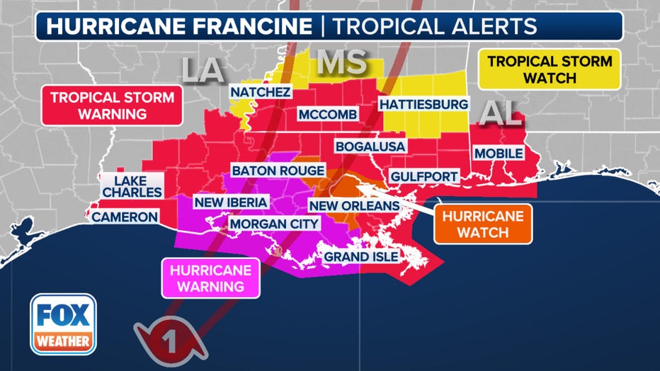
Louisiana will bear the brunt of this storm. The state could see as much as 10 inches of rain, damaging hurricane-force winds and life-threatening storm surge up to 10 feet at the coast.
The NHC has issued a hurricane warning for the Louisiana coast from Cameron to Grand Isle, which includes Baton Rouge. Tropical storm and storm surge warnings now extend from far eastern Texas to Mississippi.
Francine is the sixth named storm of the Atlantic hurricane season. There’s a danger of life-threatening storm surge as well as damaging hurricane-force winds, said Brad Reinhart, a senior hurricane specialist at the hurricane center.
LINK: Track Hurricane Francine at FOXweather.com
Hurricane Francine evacuations
Just south of Lake Charles, Cameron Parish issued mandatory evacuations on Tuesday, leaving the area eerily quiet. In Morgan City, located closer to the coast, voluntary evacuations have been put in place. Businesses are boarding up, and residents are scrambling to stock up on gas and food before the storm hits.
All New Orleans Public Schools dismissed students early on Tuesday and will remain closed on Wednesday and Thursday.
In Baton Rouge, Mayor-President Sharon Weston Broome said she has been in constant contact with the National Weather Service, along with local and state officials, as preparations are made for Francine's landfall.
"This storm is expected to bring threats of heavy rain, gusty to damaging winds and possibly a few tornadoes," she said. "I want to encourage everyone to make preparations now."