

The reason Chicago can feel 9 degrees hotter compared to the suburbs
The reason Chicago can feel 9 degrees hotter compared to the suburbs
When it is hot in northern Illinois, it is usually even hotter in Chicago. A new study shows the difference between the city and more rural areas can be significant.
CHICAGO - Heat can hit an entirely different level in the city. Climate Central has measured just how much hotter downtown, urban areas can be compared to their more rural counterparts. The difference can be startling.
Their study examined 44 major U.S. cities that collectively hold nearly one-quarter of our country's population. They calculated an urban heat island index or UHI for every census tract within the cities they studied.
The EPA describes heat islands as "a measurable increase in ambient urban air temperatures resulting primarily from the replacement of vegetation with buildings, roads, and other heat-absorbing infrastructure."
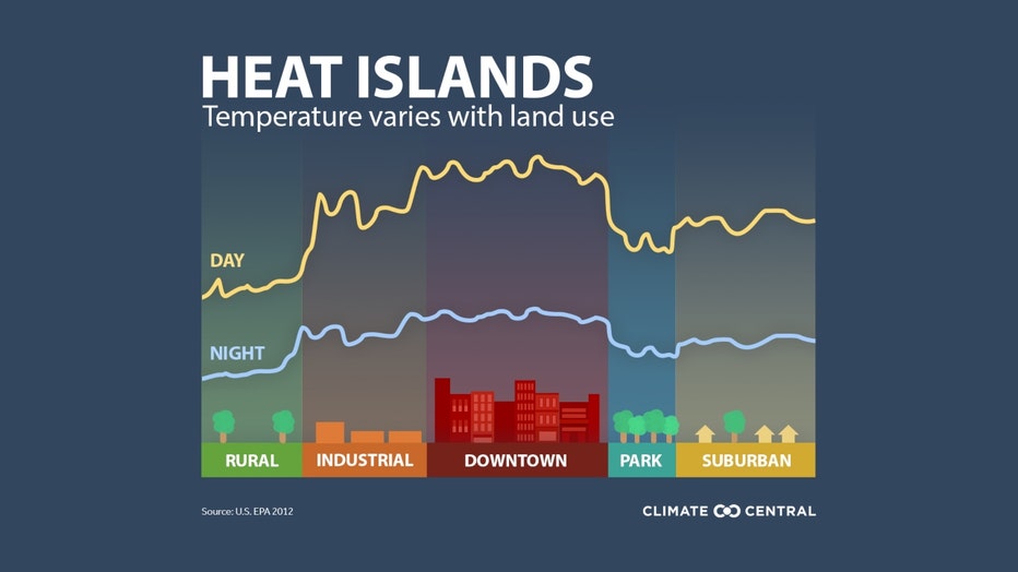
There are a variety of reasons a city can be significantly warmer than surrounding areas. The main reasons have to do with albedo, percentage of green space, and population density according to Climate Central.
SUBSCRIBE TO FOX 32 ON YOUTUBE
A surface's albedo is its ability to reflect incoming sunlight or solar radiation. Surfaces found in cities like sidewalks, parking lots, and streets have a low albedo and therefore absorb a lot of energy only to radiate back into the city.
A lower percentage of green space in a city compared to the suburbs means less evapotranspiration. That is when water evaporates off of plants, a process that cools the air. The higher population density in a city means more air conditioners humming during heat waves. The AC from urban buildings can add 20% more heat to the outside air.
Study reveals drastic temperature differences in Chicago, posing health hazard to urban residents
A new study says based on where you live within the city of Chicago, you could be facing a more intense heat compared to your neighbors.
Hotter cities mean higher health risks for their residents. Climate Central points out the following issues this raises:
During extreme heat events such as this summer’s relentless heat waves in the southern U.S., the urban heat island effect can worsen heat stress and related illness for millions, put vulnerable populations at risk, and lead to higher energy bills and strained power grids during spikes in cooling demand.
Most of the planet is warming due to human-caused climate change, but the built environment in cities amplifies both average temperatures and extreme heat. Extreme heat is the deadliest natural hazard in the U.S. Children and adults over 65 are among those most vulnerable to heat-related illness.
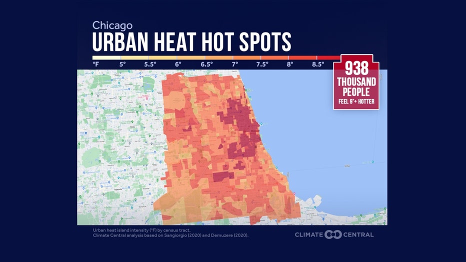
The study identified urban heat "hot spots" in the city of Chicago. The area in the map above with the darkest shade of red is where it can feel 9 degrees hotter. It is an area that impacts nearly a million people. Climate Central came up with a way to quantify the amount of extra heat impacting cities. They devised the urban heat island (UHI) index. They describe it as "an estimate of the additional heat that local land use factors contribute to urban areas".
To illustrate how to use the UHI, consider a day in northern Illinois where the temperature in a rural area is 90 degrees. That same day the temperature felt by people living or working in Chicago's Loop that has a UHI index value of 9 degrees would experience temperatures of at least 99 degrees.
Of all the cities they analyzed, nine of them exposed a million people or more to a UHI index of 8 degrees or higher. Climate Central estimated that just over 50% of Chicago's population fell in that category.
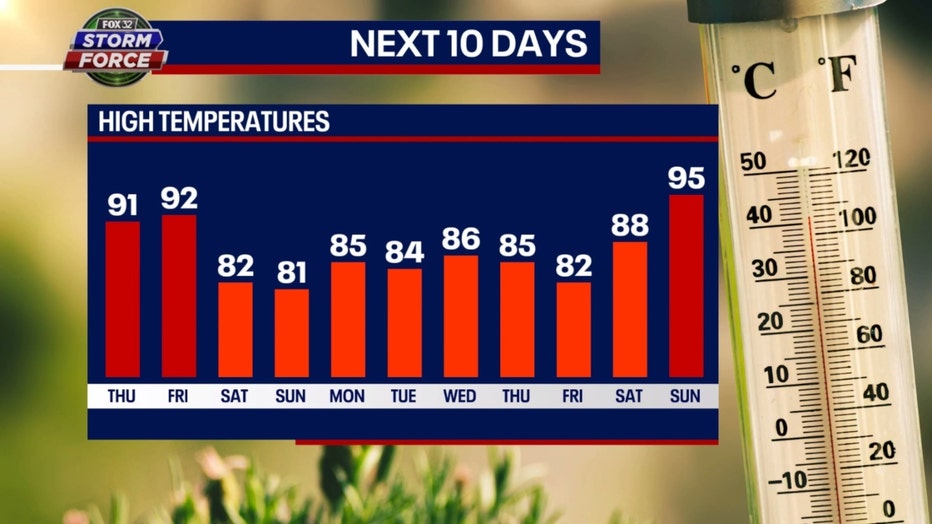
If you can hang in there with the heat Thursday and Friday, there is relief coming right around the corner. After 90s Thursday and Friday, we should cool off to around average from this Saturday to the following Saturday before more extreme heat might arrive.