

Chicago weather to be hit with drastic temperature swing
Chicago weather to swing drastically in upcoming forecast
FOX 32's Tim McGill takes a look at wild weather swings set to take place in the next 10 days.
CHICAGO - Fall is known for its dramatic drops in temperatures and the season is dialing up one for the end of October and start of November.
It will seem almost like summer today as highs hit near 80 degrees. Four days from today we will be about 25 degrees colder. Five days from now we will be about 30 degrees colder and seven days from now we'll have typical temperatures for winter, not fall. That is contingent on our Fox Model 10-day high temperature forecast verifying.
Our model has highs only in the upper 30s a week from this Wednesday. The last time we had highs that cold was in the middle of March. This will be the coldest outbreak we have seen in nearly six months. Today's high is what we expect in the middle of June and next Tuesday's high is what we expect in the middle of December.
The longer-range temperature outlooks from the Climate Prediction Center show a strong signal for a cold outbreak too.
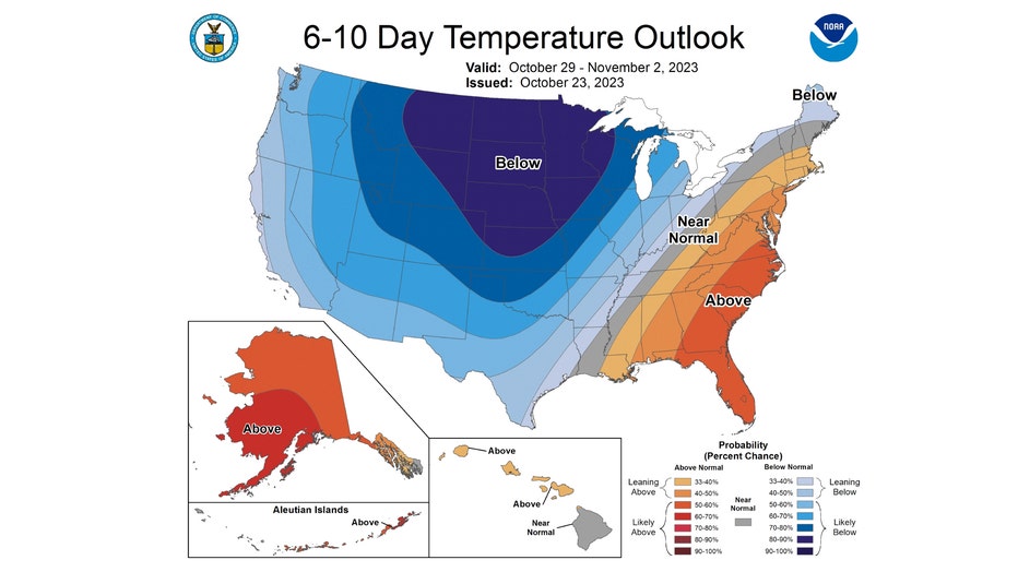
The 6-10 day temperature outlook has most of northern Illinois "likely below" normal overall. This covers the period of Sunday through the following Thursday. There is an awful lot of blue on this map which is indicating a major pattern shift for next week.

Still a lot of blue on the 8-14 day temperature outlook. It keeps the relatively colder pattern coming through nearly the first week of November. It has northern Illinois "likely below" normal from Halloween through the following Monday.
Speaking of Halloween, it is about the average date we see the first flakes of snow fly here. That makes the day even more scary.