Chicago weather: Winter one-two punch could be coming
Chicago weather: Winter one-two punch could be coming for Chicago
FOX 32's Tim McGill looks ahead to some nasty winter weather coming to the Chicago area.
Chicago - Winter has been a breeze so far for Chicago. Every day that goes by sparing us snow and bitter cold makes me more anxious about what is to come.
When will our luck run out? We have seen just over an inch of snow since Dec.1 which means we are now running nearly 9 inches below average in terms of snowfall.
December was remarkably mild with an average temperature nearly 9 degrees above normal. January is now running about 5 degrees above average. The latest forecasts strongly suggest that our relatively mild winter may be transitioning into a more harsh pattern next week. It may be a one-two punch with an early week snowstorm followed by the arrival of some Arctic air to bring a frigid finish to January.
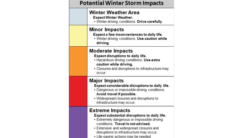
There is consensus among the computer models that a major winter storm will impact the Midwest next week. The exact timing, track, and intensity of the storm are still in a forecast flux.
It now appears the system will sweep precipitation into Chicago sometime early Tuesday and continue into early Wednesday morning. NOAA's Weather Prediction Center has categories for how impactful a winter storm could be, and they range from "minor impacts" to "extreme impacts".
My early hunch is that this storm will have at least moderate, and perhaps major impacts on the Chicago area. By definition, that would mean considerable disruptions to daily life, hazardous driving conditions, and even the possibility of some road closures either here or nearby.
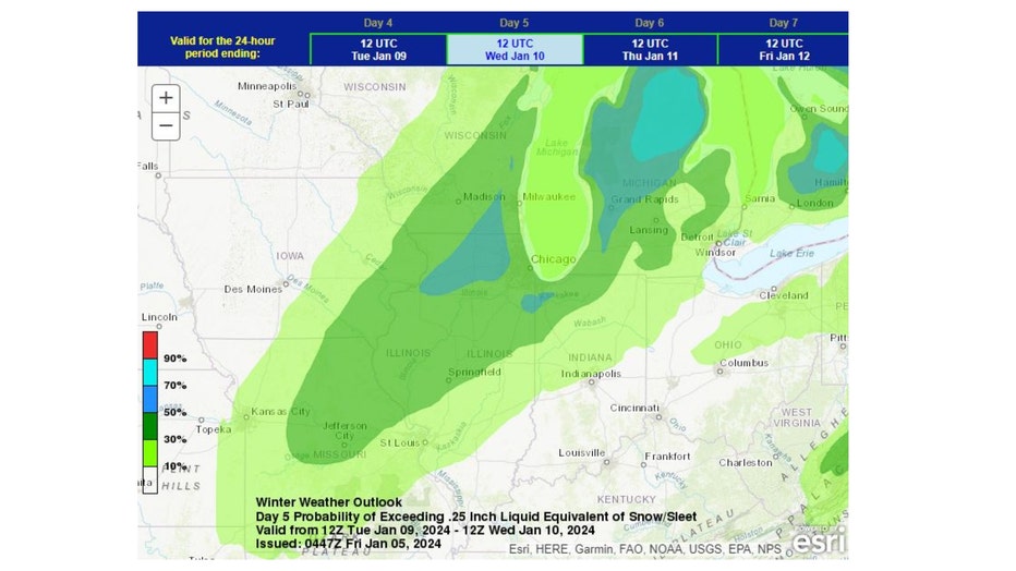
NOAA's Weather Prediction Center's winter weather outlook has us in the crosshairs of the storm with the heaviest precipitation placed almost directly over us. Still too early to talk about exact snowfall amounts. The limiting factors in terms of snow are a lack of Arctic air to fuel the storm and a strong wind off the relatively warm waters of Lake Michigan that will at least cut down on possible snow totals lakeside. The dynamics and energy of the storm can compensate for some of that with several inches of snow possible in the path of the storm.
The problem is the path or track of the storm isn't clear this far out. It appears parts of the Midwest will be favored for primarily snow, but other parts will see more of a mix of rain and snow. Northern Illinois may be near that critical rain-snow line. As of Friday morning, the system is still evolving and more than 4000 miles away in the Gulf of Alaska. A lot could change between now and Tuesday.
There are some things that we can say with confidence at this juncture about the storm. It will feature heavy, wet snow and strong winds. That is the first punch Old Man Winter will throw, with the second possibly coming a few days later.
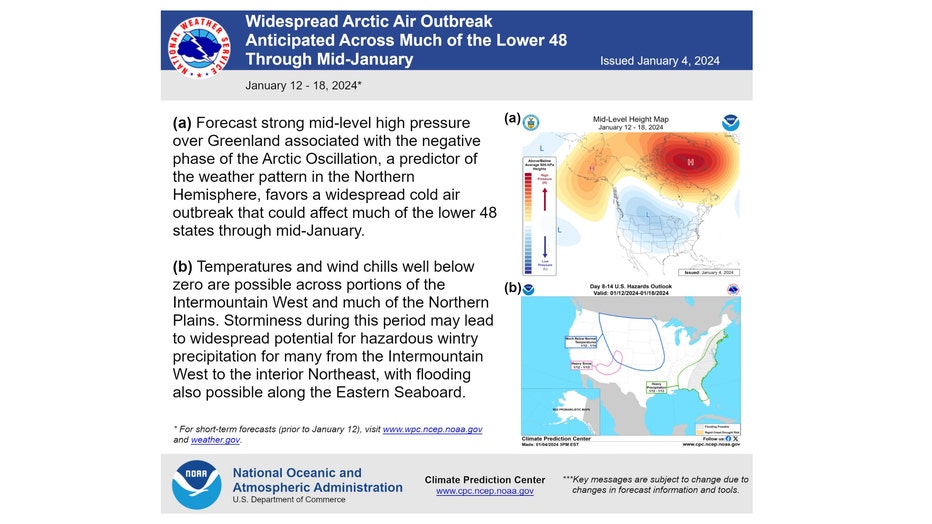
Many models are hinting at a colder pattern coming around the middle of this month. Some Arctic air may be dislodged and driven south with an arrival here sometime towards the end of next week. NOAA's Climate Prediction Center thinks it could be significant, so they issued a kind of heads-up that gives some details on what may be to come.
The longer-range temperature outlooks from the Climate Prediction Center seem to corroborate the colder pattern that is coming.
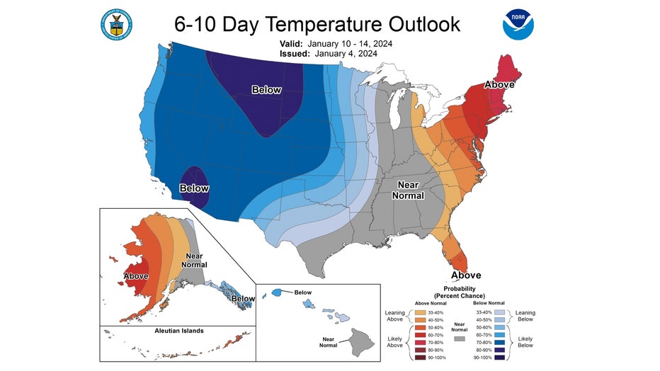
The 6-10 day temperature outlook forecasts northern Illinois and Indiana to be "near normal" overall. This covers the period from next Wednesday through the following Sunday.
While it may seem like "nothing to see here", look out west. There is an ominous blob of blue indicating more than half the country favored to be below average overall. That blue bleeds east and shows up here in the CPC's 8-14 day temperature outlook.
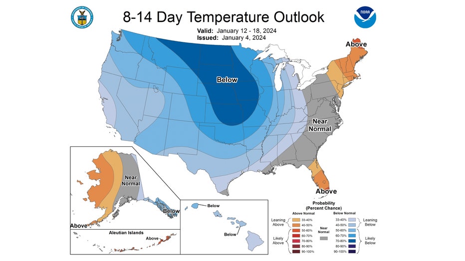
The 8-14 day temperature outlook has us buried in blue and "likely below" average. This covers the period from next Friday through the following Thursday. So the main message is we shouldn't fall for the false sense of security that this winter has given us so far.
We are days away from receiving the beginning of a double dose of real winter weather.

