

Chicago weather: 'Real' winter may be just around the corner
Chicago - We are just over a third of the way through winter and have yet to see any bitter cold or substantial snow in Chicago.
So far this season we have seen just two days with below-average temperatures. December was remarkably warm (relatively speaking). The average temperature for the month was 39 degrees, tying it with 2015 as the 4th warmest December on record.
Snowfall has been sparse. The 1.2 inches that fell last month means December 2023 was among the top 11% least snowy Decembers on record. The most snow from a single storm so far this winter was .9 inches, which fell on Dec. 31.
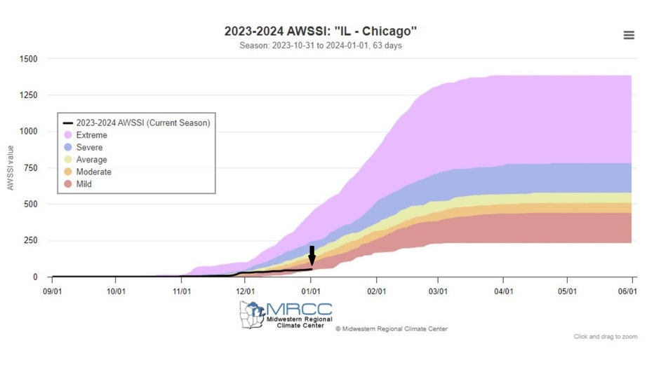
The "Accumulated Winter Season Severity Index" or AWSSI (or "misery index") calculated by the Midwest Regional Climate Center is an ongoing measure of the severity of the season. The categories in order from least miserable to most include mild, moderate, average, severe, and extreme. Through the start of 2024, this winter ranks as mild with an index of just 51. The higher the number, the worse the winter. To put our current standing into perspective, the highest the index has reached through Jan. 1 is 493 and the lowest it has reached through that date is 42.
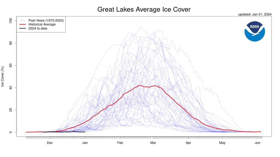
We can also look to the lack of ice on the Great Lakes for another sign of just how easy this winter has been so far. The lack of cold means a lot more open water compared to the average.
At the start of 2024, just less than half a percent of the Great Lakes had ice cover. It was the smallest amount of ice cover in at least the past 50 years for New Year's Day. We should be seeing about 9% ice cover by this time of the winter.
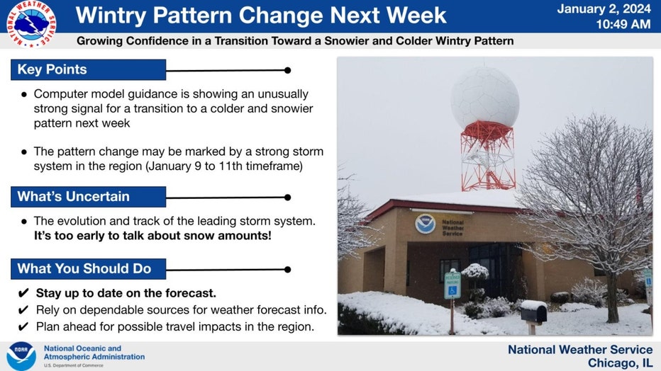
The Chicago office of the National Weather Service is alerting people to the strong possibility of a major pattern shift coming in just a few days. They note that there is a growing consensus from computer models suggesting a markedly colder pattern coming soon. They also mention a potential storm that could spell several inches of snow for parts of the Midwest early next week. Too soon to get specific about snowfall amounts, but this is a heads-up to an abrupt change to what has been a mild winter pattern thus far.
Some flurries today will be followed by some snow showers tonight, but little or no snow accumulation is expected. We have seen just 1.2 inches of snow so far this winter. On average, we have 8.2 inches by now. We could put a dent in that deficit next week. The timing for next week's storm is somewhere in the late Tuesday to early Wednesday timeframe.
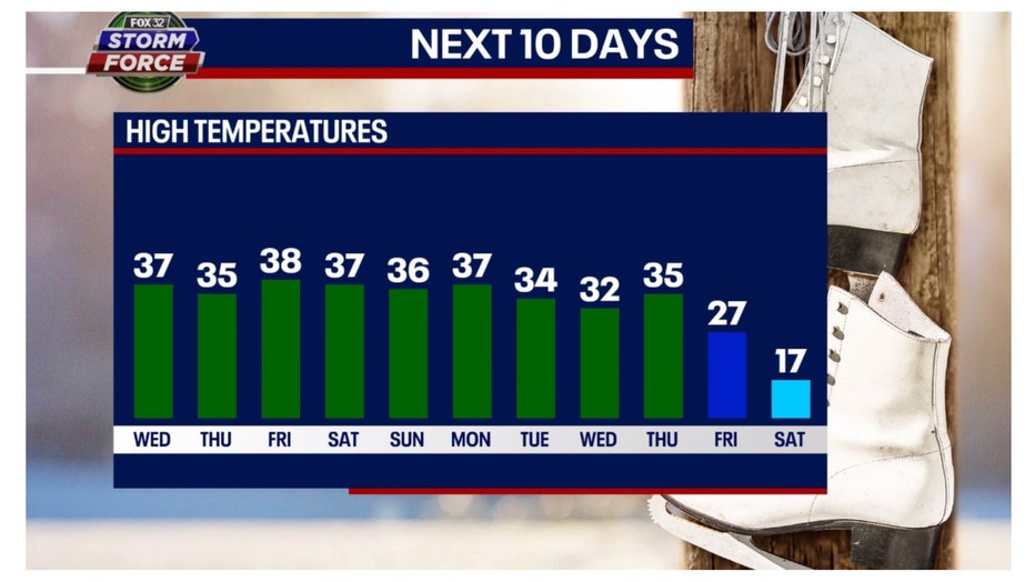
This assumes it will be cold enough for snow next week. Our long-range Fox model does keep it cold enough for some snow. It brings in a more bitter brand of cold by the end of next week with highs a week from this Friday falling into the 20s and then only hitting the teens a week from Saturday. These numbers will be at least tweaked between now and then.
The longer-range temperature outlooks from the Climate Prediction Center also hint at a colder pattern coming next week.
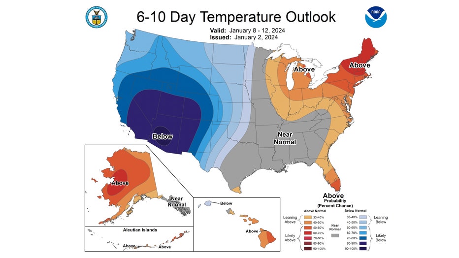
The 6-10 day temperature outlook forecasts northern Illinois and Indiana to be "leaning above" normal overall. This covers the period from next Monday through the following Friday. The brown shades are replaced by blue hues in the CPC's 8-14 day temperature outlook.
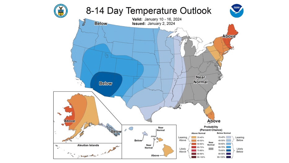
The 8-14 day temperature outlook has us "leaning below" average. This covers the period from next Wednesday through the following Tuesday. Notice how the big blob of blue expands eastward in this forecast.
The last few days have seen a return to about average temperatures. If you haven't broken out the thicker winter jacket by now, you have some time to dig it out of the closet. Don't forget to find that snow shovel too, you just might need it at some point next week.